


2026-09-17 21:24:59
For 404 Media, Jason Koebler collated the dumb emails they receive from dumb AI agents that are ruining the internet experience.
Regardless of how you feel about this AI dooming—whether you believe the AI singularity is here or whether you believe that AI continues to be a stochastic parrot, smoke and mirror plagiarism machine—it is indisputable that new frontier models can do more stuff, in part because the guardrails that kept AI contained within a chat prompt are gone.
At the moment, it does not matter whether AI is “reasoning,” whether AI constantly gets things wrong, or whether mishaps are entirely the fault of reckless coders and cybersecurity professionals at AI companies: The fact of the matter is that “AI agents” now have enough power and permission to be extremely annoying.
I get a lot of these emails. I assume it’s a volume game like sending a million Nigerian prince emails, but that at least had a payoff for scammers, right? The pretend emails feigning interest in people’s work (or promises of rare datasets in my case) is just volume annoyance.
2026-09-17 21:06:24
This is issue No. 406 of the Process, where we do not settle for defaults. I’m Nathan Yau. This week, there were a lot of trade-offs between utility and aesthetics. How do you find the balance?
Become a member for access to this — plus tutorials, courses, and guides.
2026-09-17 17:30:49
For the Verge, Lauren Feiner visited Loudoun County, Virginia, which used to be the location of AOL headquarters. After the dot-com bust, the county opened the empty AOL buildings and infrastructure to data centers. The plan worked and was humming along, until the past couple years when hyperscalers suddenly needed a lot more space and resources.
Loudoun County residents are also starting to take notice. Within the past few years, data centers have been elevated from an unremarkable part of daily life in Loudoun to something that many residents now think about every day. For some, it’s the constant hum they hear from their decks; for others, it’s the transmission towers that loom over their favorite green space, or the surprise call from their energy utility that one of those towers could go up in their own backyard. While residents recognize that data centers have brought a lot of prosperity to the county, they’re beginning to wonder how much more they can take.
The residents interviewed in this story seem about as conflicted as the people using generative AI. On the one hand, the technology brings benefits to the community in the form of jobs, reduced property taxes, and increasing home values. On the other hand, some neighbors get a giant tower built in front of their home’s sight line or light shining through their windows all night.
Tags: data center, reality, Verge
2026-09-16 18:24:08

Open Peeps by Pablo Stanley is a library of people illustrations. You can mix and match clothes, faces, hair, and bodies for a wide array of characters.
Tags: illustration, Open Peeps, Pablo Stanley
2026-09-15 17:47:04
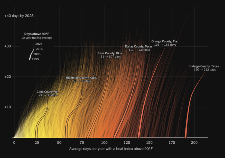
Summer 2026 is likely the hottest summer on record since 1895. The NYT editorial board describes the warming days and warns of what is to come.
In many parts of the country, extreme heat affects much more of the year than it once did. In the late 1980s and early 1990s, Fulton County, Ga., which includes Atlanta, spent about 47 days a year with a heat index (a measure that combines temperature and humidity to estimate how hot it feels) exceeding 90 degrees. In recent years, Fulton County’s residents have typically endured 79 such days, an increase of a month.
There are several charts and maps by graphics editor Gus Wezerek. The introduction chart, shown above, looks like radiant lines rising off a hot surface.
It’s a clever use of a connected scatterplot. The x-axis is the average days per year with a heat index above 90 degrees Fahrenheit, using a 10-year moving average. The y-axis is the difference between points in time. Points are connected from 1995 through 2025.
Tags: climate change, heat, New York Times
2026-09-15 15:36:08
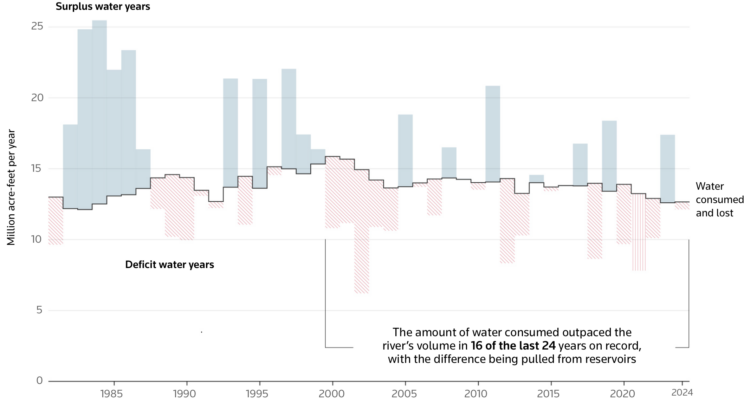
The Colorado River is at risk due to drought and states using more than the river provides. For Reuters, Travis Hartman and Andrew Hay mapped and charted how volumes have changed over time.
Water use peaked in the late 20th century. Consumption has eased since, but the U.S. still draws more from the Colorado than the river provides — a gap widened over the past two decades by a megadrought that has pulled reservoir levels sharply lower.
This is a very flow-centric piece. It starts with a moving water line, which ends up being the top of a Sankey diagram. The bar chart uses the same water pattern that moves a little bit at the top. Then there’s a map of the actual river.
Tags: Colorado River, consumption, drought, Reuters, water

