2026-07-02 22:32:34
This is the 2nd premium article of the week. I’m near the end of the architecture series. Today, we’re going to cover the last piece of the puzzle: How the Industrial Revolution changed architecture. The next article on the topic will be why are buildings ugly today, and the last one will be about how to make beautiful buildings.
I’m going to be writing …
2026-06-29 22:57:08
This is the 6th article on architecture. In the first two we saw how local climate and materials determined architecture in the Mediterranean and in Asia. We then saw how Romans had novel architectural needs and created technology to satisfy them, leading to a new style of architecture. Christians later pushed that technology to build inspiring cathedra…
2026-06-23 21:41:33
I’ve been thinking about this and gathering insights for 10 years. I don’t know of another analysis that maps Christianity’s rise this systematically as a growth engine.1
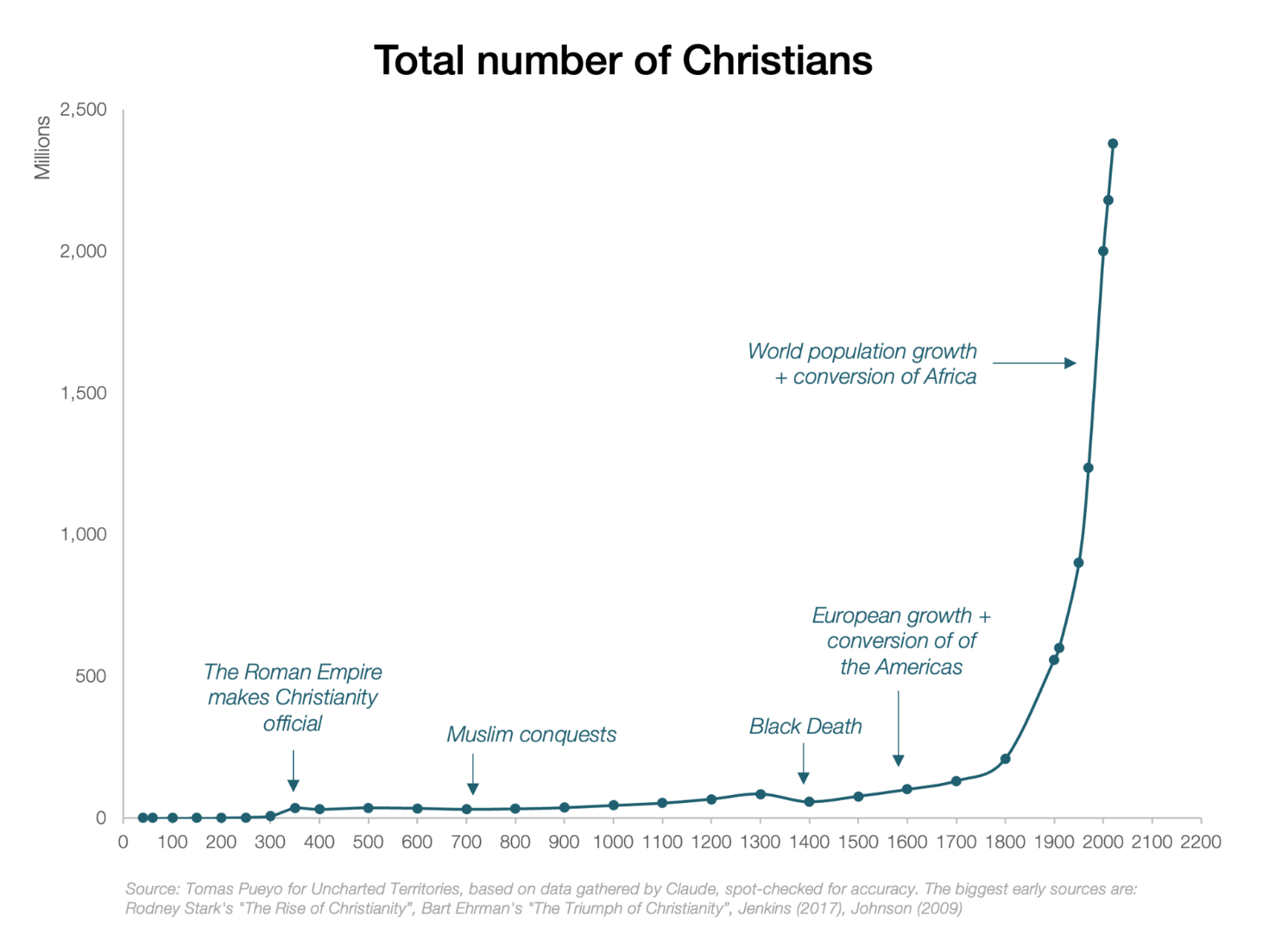
Christianity is the biggest religion in the world: ~2.3B people, nearly 30% of the world’s population.
Why has it been so successful?
Based on that chart, you’d probably assume that most growth happened in the last few centuries: From the European conquest of the Americas in the 1500s onwards, to the conquest of Africa in the late 1800s, and the 20th century baby boom.2
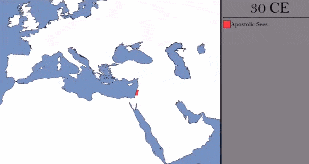
If instead you looked at this map of the early growth of Christianity, you’d suspect something different:
From this, you’d guess that the big milestone of Christian growth was the takeover of the Roman state in the 300s AD.3 Well, here’s the same graph as above, but logarithmic:
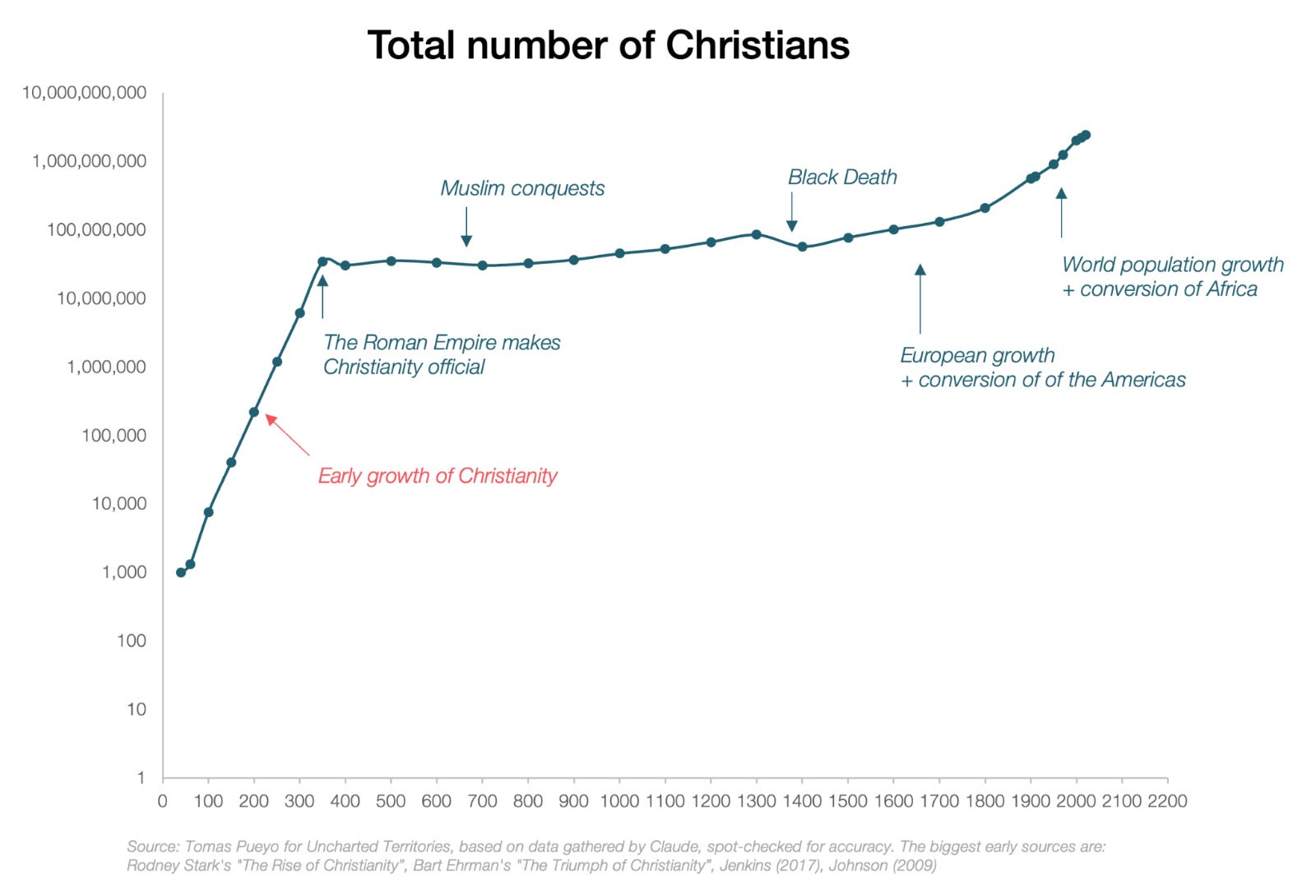
In fact, Christianity grew like crazy until it took over the Roman state! From ~1000 followers around the time of the death of Jesus, to ~35M when it became the official religion of Rome, Christianity grew by ~40% decade over decade.4 How is that possible? How did a ragtag group of Jews from a frontier colony of the Roman Empire create a new religion that took over the most powerful empire, and from there the world?
In my previous careers, I created and grew software, including viral applications. The insights on viral growth are what allowed me to quickly understand COVID, and when I look at the rise of Christianity, I see the exact same patterns: a piece of software hyperoptimized for growth.

Indeed, Christianity, like all religions, is software, an operating system that guides people on what they should and shouldn’t do. And Christianity optimized every aspect of its business for growth:
Big audience
The value proposition of its product
The segmentation, to specialize in a few key audiences
Advertising, to spread the message to new audiences
The sales force
Low friction to convert customers
Viral growth: Existing customers attract new customers
“Reproduction rate” (growth within existing customers)
Retention rate: The degree to which you keep your audience
Competition suppression
Customer monetization
Today, we’re going to look at each.5
A good business has a huge TAM, or Total Addressable Market: All the people who can potentially consume the product.
Christianity comes from Judaism, but Jews think they are Chosen People: Only them have been chosen by God to receive the Torah and follow his commandments. It’s a religion mixed with an ethnicity. A private club. Back then, virtually all religions were private clubs.
Christianity killed that and declared itself open to all:
There is neither Jew nor Greek, there is neither slave nor free, there is no male and female, for you are all one in Christ Jesus.—Galatians 3:28
Religion gets disconnected from ethnicity.
Does it though? No! That’s not what Jesus said! He said to try to convert Jews only!
Go nowhere among the Gentiles, and enter no town of the Samaritans, but go rather to the lost sheep of the house of Israel.— Gospel of Matthew
I was sent only to the lost sheep of the house of Israel.— Gospel of Matthew
The ones to increase the TAM were his disciples; that first quote was from Apostle Paul. Why would the apostles change Jesus’s message? Because they had to travel across the Mediterranean to convert Jews, who lived in pretty mixed communities: Many Jews only spoke Greek, and they were surrounded by pagans. By accepting non-Jews, early Christians dramatically grew the TAM,6 and with it the scope of Christianity.7
The Christian pitch was so much better than that of the competition that good missionaries could convert thousands of people. For example, after the apostle Peter preached to a multitude:
There were added that day about three thousand souls.—Acts 2:41
How was the pitch so competitive?
Greek & Roman life was pretty brutish, violent, and mean. Think Roman circus.
Judaism was an improvement on that: Although the Jewish god is feared, and Judaism focuses on Jews, it does preach loving each other and thy neighbor.
Christianity went further though:
You have heard that it was said, "An eye for an eye and a tooth for a tooth." But I say to you, Do not resist the one who is evil. But if anyone slaps you on the right cheek, turn to him the other also.— Jesus Christ (Matthew 5:38–42)
When mixed with universalism (everybody can be Christian) and the mutual obligation to help each other, this message became extremely powerful. It created a community of people who were morally much more admirable than the competition, and who gathered in loving and kind community.
All of this was very counterintuitive at the time! You can imagine how compelling that pitch would have been.
When you design videogames, you learn that the single most important motivator to a player is actionable progress, whether through reactions to your actions (e.g. you shoot, somebody dies), level or quest completions, progress bars, points… You can act, that action brings progress, and that progress is visible.
Polytheisms tended to be terrible at this: You, the player, were subject to the whims of gods. You couldn’t really know what they wanted; you had to guess. You performed some sacred rite and hoped it worked. You didn’t know what parts worked, so you just tried to get it as close as possible to the time when somebody did something similar and ended up lucky.
Christianity changed all that. You knew exactly what you needed to do (love, respect and help others, etc.); even if you failed you could still get back on the wagon; you could comment on your progress with a priest (confession), who would tell you what you needed to do to get back on track (penance)... Based on all this, you had a pretty good sense of whether you were going to end up in heaven or hell.
In the ancient world, the point of religion was for gods to help you, to get supernatural help… miracles. If your god couldn’t make them, she was weak. Christianity claimed that it could perform lots of miracles. A healing or exorcism was a public demo. Even when a miracle was only reported, the report itself traveled as social proof.
That belief translated into specific benefits.
Let the strong care for the weak, and let the weak reverence the strong. Let the rich man bestow help on the poor and let the poor give thanks to God.—First Letter of Clement to the Corinthians
Christianity was a mutual-aid society. People took care of the poor, of the sick, of the neighbor in need.
This was especially valuable in the past, because the world in general, and cities in particular, were extremely dangerous: disease, fire, famine, abandonment, patronage dependence, widowhood, infant mortality, slavery, migration… The Church gave members a second family.
In this way death, waging war with these two weapons, pestilence and famine, destroyed whole families in a short time, so that one could see two or three dead bodies carried out at once… Then did the evidences of the universal zeal and piety of the Christians became manifest to all the heathen. For they alone in the midst of such ills showed their sympathy and humanity by their deeds. Every day some (Christians) continued caring for and burying the dead, for there were multitudes that had no one to care for them; others collected in one place those who were afflicted by the famine throughout the whole city, and gave bread to them all; so that this thing became noised (spoken of) abroad among all men, and they glorified the God of the Christians and, convinced by the facts themselves, confessed that they alone were truly pious and religious.—Eusebius, Historia Ecclesiastica, 324 AD8
Did this matter? So much so that the emperor Julian launched a campaign to meet the value proposition:
Julian complained in a letter to the high priest of Galatia in 362 that the pagans needed to equal the virtues of Christians, for recent Christian growth was caused by their “moral character, even if pretended,” and by their “benevolence toward strangers and care for the graves of the dead”.—The Rise of Christianity, Rodney Stark
This was even more compelling in times of crisis like famines, pests, or earthquakes, when society fell apart except for the Christians. If you lost everything and none of your pagan priests were there for you, but the Christian community was surviving together, that made for a pretty compelling sales pitch.
Showing love, gathering together, helping each other… They were patient, disciplined, peaceful, sexually restrained, generous, willing to suffer… These are things no other religions did. The product demo was great and unique.
This was even truer of Christianity’s power users: monks, virgins, martyrs, confessors… Their costly self-denial made the product more credible, like a product’s community having power users as evangelizers, a name used to this day for this purpose in software products.
As I’ll describe in the next article, the older religion of Zoroastrianism had invented a version of heaven and hell, which Judaism had adopted. But the process was slow, lasting centuries. Initially, people believed there was nothing after death. Then, a state of stasis. Then, that all the dead would eventually rise on the final judgment day, and the good would be rewarded and the bad punished. Then, that during the waiting period, the good would have a more pleasant experience than the bad. That last part is closest to what Jesus believed.
Early Christians made an addition: They made heaven and hell destinations you enter just after death. Why? Well, Jesus had just died and been resurrected within 3 days, so that proved it could happen fast. And where was Jesus now? The final judgment day had not arrived, so he must be somewhere. That somewhere had to be pretty cool, right?
CHRISTIAN PROSELYTIZER: Did you know there’s a life after death, and it lasts for a very long time, and if you’re good you get an amazing place to enjoy until the final judgment, and if you’re bad you suffer?
ROMAN: How do you know that’s true?
CHRISTIAN: Well, Jesus died and was resurrected. We have plenty of witnesses. How do you know it’s NOT true? Are you willing to risk suffering for what could be forever?
ROMAN: Hmm…
CHRISTIAN: Oh and by the way, the one who makes that judgment is my God. And he sees EVERYTHING and can do ANYTHING. Unlike your weak gods.
ROMAN: Sh*t… OK where do I sign?
This creation of a clearer vision of heaven and hell where your soul goes while you wait for the final judgment really gelled as Christians mixed with Greeks. Early on, Christians thought resurrection was literal (the body came back). But with Greeks, who conceptualized the duality of body and soul, the idea became sturdier: Clearly, the bodies of the dead were not coming back, and many Christian martyrs were being persecuted. There was urgency to come up with a solution for them to continue believing in Christianity. That’s how the idea of a soul leaving your body and flying to the sky to hang out with Jesus emerged.
Later on, the Church would make heaven a kick-ass place and hell the worst place ever, forever. They were basically the biggest stick and carrot you could conceive, if you wanted your flock to do as you say. Pretty convenient.
Meditation is good for the mind, and later on in the history of the Church, everything around mass was designed to induce a meditative state:
When you enter a church (even more so a cathedral), all your senses awaken, as if you were passing the threshold into a sacred space. The temperature is different from outside due to the solidity of the walls and the height of the ceiling; light is filtered through colored glass, sound is quiet and the little noise reverberates as if everything was a murmur, the smell of incense lingers… All its architecture is designed for this.
I think most sermons are designed to be boring. It’s not a coincidence that the word litany originally refers to a prayer led by a priest, and has come to mean a long, monotonous, or repetitive catalog of complaints or issues. Boring sermons achieve two goals: Suffering them in silence displays adherence to the belief, but more importantly, they induce a meditative trance. People escape their minds for a moment, their thoughts, very much like guided meditation
The topics push the audience to reflect, to take stock of life and to project into the future.

At the time of Jesus Christ (JC), the main target segment to convert to Christianity was Jews.
Like many other ethnicities (Greeks, Romans), Jews had spread through the Roman Empire, mostly as traders and artisans, which meant they stayed primarily in cities. Unlike other ethnicities though, they preserved their Judaism strongly, so that there were Jewish communities in cities around the Mediterranean—a perfect target for conversion. That’s why early Christian missionaries traveled so much around the Eastern Mediterranean. It’s also why most early conversions of Christians were in cities. The word “pagan” originally meant “rural”...
Being far from Israel, these Jews were likely less orthodox. Some were integrating into their host cities already, and were probably easier to convert.
Many Gentiles would have become adjacent to Judaism, but might not have converted yet. Remember, it was a private club, not easy to join. So if a religion adjacent to Judaism appeared and made it easy to join, it would have been quite successful.
You might well say your TAM is everybody, but if you don’t speak their language, your product won't travel far. So as Christian proselytizers traveled around the Mediterranean, they adapted their texts to local languages.
Christians went beyond translation. For example, when the Church had to translate religious texts into Slavic (which didn’t have an alphabet), they created the Cyrillic Alphabet.
Women in general are a better target than men for early conversion to a new religion: They tend to make up the biggest share of new members in cults, are more religious, more prone to believe in the supernatural (e.g. astrology), and in certain circumstances are more easily persuaded9.
And in the Ancient World, they were the most underserved audience.
The status of Athenian women was very low. Girls received little or no education. Typically, Athenian females were married at puberty and often before. Under Athenian law, a woman was classified as a child, regardless of age, and therefore was the legal property of some man at all stages of her life. Males could divorce by simply ordering a wife out of the household. Moreover, if a woman was seduced or raped, her husband was legally compelled to divorce her. If a woman wanted a divorce, she had to have her father or some other man bring her case before a judge. Finally, Athenian women could own property, but control of the property was always vested in the male to whom she “belonged”.—The Rise of Christianity, Rodney Stark, via Astral Codex Ten
Meanwhile, Christians thought everyone was equal under God, and that having sex created an exclusive covenant that created an eternal bond between men and women.
The two shall become one flesh.—Jesus, Matthew 19
As a result, Christianity condemned divorce, incest, marital infidelity, and polygamy, all of which are bad for women (who could lose their status and income, or have to share their husband’s wealth with other women), especially for high-status women (who had the most to lose).
Also:
No early marriage: Christian girls were two thirds less likely to be married by age 13 than pagan women.
No forced remarriage after becoming a widow: Widows were pressured to remarry under Roman law (and thus lose their inheritance, which became their husband’s), but not in Christianity.
Status: Women could also hold high-status office in the Christian Church.
The result was a lot of early conversion of women:10
The early church was so especially attractive to women that in 370 the Emperor Valentinian issued a written order to Pope Damasus I, requiring the Christian missionaries to cease calling at the homes of pagan women. Although some classical writers claimed that women were easy prey for any "foreign superstition," most recognized that Christianity was unusually appealing because within the Christian subculture women enjoyed far higher status than did women in the Greco-Roman world at large.—Reconstructing the Rise of Christianity: The Role of Women
Slaves also seem to have been a significant part of the early Church and in some cases even found themselves in leadership roles. Early Christian communities were accused of targeting the illiterate, enslaved, young, female and under-educated.—Brett Devereaux
This makes sense, as the people most likely to want to upend the system are those who are losing in the current one. The same was true for communism 1800 years later.
Has not God chosen those who are poor in the eyes of the world to be rich in faith….is it not the rich who are exploiting you? Are they not the ones who are dragging you into court?—James 2:5
Peter Turchin has this theory that lots of revolutions are caused by secondary elites, who are close enough to power that they can see it and experience it, but for whom full access is barred. They become the angriest and tend to lead revolutionary movements. That’s indeed the segment that Christianity targeted:
The main strength of Christianity lay in the lower and middle classes of the towns, the manual workers and clerks, the shop keepers and merchants—Jones, 1963
All of this makes a lot of sense. If you want to take over an existing power system, you have to create a coalition of the losers of the existing system. That means you must take the power away from those who currently have it.
Go, sell your possessions and give to the poor, and you will have treasure in heaven. Then come, follow me.— Matthew 19:21
This is why it was so important for the spread of Christianity that Jesus shun the rich. By telling them they won’t reach heaven through riches, and that they must give to the poor instead, he was able to get the resources needed to broaden Christianity’s reach.
It is easier for a camel to go through the eye of a needle than for someone who is rich to enter the kingdom of God.—Mark 10:25 / Matthew 19:24 / Luke 18:25.
That said, the rich are by definition more powerful, so more likely to fight back and with the resources to do it. The only way to win there was to make Christianity intellectually respectable. A religion of fishermen, slaves, widows, artisans, and urban migrants could grow from below, but to conquer the empire it also had to climb the prestige ladder. Many Christian thinkers worked to reframe Christianity as a true philosophy that had superior answers to the questions Greek philosophy had been asking for centuries.11
The blood of the martyrs is the seed of the church.— Tertullian, Apologeticus 50
Normally, when you kill people for belonging to a religion, that religion weakens or disappears. But when Christians were persecuted in the Roman Empire, the religion spread. Why? A lucky combination of factors:
Rome didn’t systematically eradicate Christians, mainly because Christians were generally good: They respected the state and gathered to sing and to tell each other to be good people. The killings were sporadic, and frequently done for show.
Christians were not just killed, they were asked to convert or die. Many decided they’d rather die. What a great marketing message! See? He’s so sure this is the right religion that he’s willing to die for it.
Part of this acceptance of death was from the section above, the introduction of the concept of heaven & hell. Christians thought they were going to heaven.
This is even more true when Christians were killed because of their belief. They became like Jesus, martyrs for the belief. That was compelling. Muslim suicide bombers have also willingly died as martyrs, and today many people wish to become martyrs in Islam.
The Roman display of killing Christians was meant to inspire fear, but it backfired because Christians would endure these ordeals with unusual composure, which inspired others: They truly believe in their religion, they truly believe in an afterlife, they truly believe they should act like Jesus, because they’re willing to die for it. Therefore, Christianity must be the way to go.
This, by the way, is probably why Romans tended to avoid killing Christians, as Roman leaders knew they’d become martyrs to the cause. Christians, taking power later, no doubt tweaked the story to make it look like they had been persecuted more than they actually had been.

“[Martyrdom] was a glory that was open to all, regardless of rank, education, wealth or sex.—Catherine Nixey
That said, the execution of Christians for religious nonconformity was extremely rare, since most Roman rulers were smart enough to realise that there is nothing to be gained from making religious extremists into heroes. In 111 CE, Emperor Trajan insisted in a letter to Pliny, the governor of Bithynia, that he should punish only the most recalcitrant rebels; anyone willing to offer prayers to “our gods” could be pardoned, “however suspect his past conduct may be”.12
Greco-Roman religion was very visual: temples, statues, processions, sacrifices, sacred objects, priestly costumes, inscriptions... Early Christianity began comparatively light on its visuals, so that’s not very competitive. So it quickly developed its visual brand: codices, crosses, fish, anchors, Good Shepherd imagery, and later basilicas, mosaics, icons, relic containers, and sacred architecture. We’ve talked in the past how much the Church pushed Gothic architecture for example as a way to inspire Christians.
If you have a great product, a big market, and plenty of effective advertising, it’s time to unleash your sales force. And Christianity had a very good one.
Jesus asked his disciples many times to spread the Gospel: “Follow me, and I will make you fishers of people”, “Proclaim the kingdom of God”, “The good news must first be proclaimed to all nations”, “make disciples of all nations”, “As the Father sent me, so I send you”... And they did. They traveled far and wide to spread the Gospel, especially Peter and Paul.
Traveling healers were common at the time. Christianity adapted that role for its missionaries, adding the teaching component, using that mechanism as another channel for growth.13 It was easy, since Jesus had been a traveling healer, too. So we can view part of Jesus’s life as modeling the traveling salesman role to teach his disciplines the craft.
APOSTLE JOHN: We have not been taught to be physicians. How then will we know how to heal bodies as you have told us?
JESUS: Rightly have you spoken, John, for I know that the physicians of this world heal what belongs to the world. The physicians of souls, however, heal the heart. Heal the bodies first, therefore, so that through the real powers of healing for their bodies, without medicine of the world, they may believe in you, that you have power to heal the illnesses of the heart also.—Acts of Peter
This actually allowed Christianity to differentiate itself from the competition through miracles. In Greek and Roman times, most miracles were site-based. You had to travel to a place to benefit from them. But Jesus tied them to his name, and from there, missionaries also became mobile miracle workers, allowing the stories of miracles to travel further.
You’re telling me all these stories of a guy who died and then was resurrected, he walked on water, he turned water into wine… That sounds pretty preposterous to me. How do I know it’s true?
Extraordinary claims require extraordinary evidence, which could not be provided for these types of claims.14 Yet good salespeople are prepared to handle their prospects’ objections. So what did Christianity come up with? A role model.
St Thomas was the skeptic apostle15 and he didn’t believe that Jesus had died and rose again. “I’ll believe it when I see it.” So according to the Bible, St Thomas did see Jesus and did touch his wounds, at which point he believed. Then Jesus said:
Thomas, because thou hast seen me, thou hast believed. Blessed are they that have not seen, and yet have believed.
In other words, suspend your disbelief and start accepting the claims without verification.
This is reinforced elsewhere in the Bible:
We live by faith, not by sight.—2 Corinthians 5:7
Trust in the Lord with all your heart and lean not on your own understanding.—Proverbs 3:5-6
The foolishness of God is wiser than human wisdom.—1 Corinthians 1:18-25
One key innovation by the Medieval Church to its sales force was making its main employee base—priests—celibate:16 They’d dedicate their entire lives to the Church without diluting their efforts. More importantly, having children creates a conflict of interest, as what’s good for the children (inheritance) is not good for the Church (accumulating wealth). No children, all your efforts go toward growing the Church.
If you have a strong sales pipeline, but your prospects don’t convert to customers, you will be wasting your time.
Judaism had what we call a high friction acquisition funnel for men: You had to cut a piece of your penis. Imagine what the end of the sales pitch sounded like: “There’s one last little detail that I haven’t mentioned yet…”.
You also had to follow plenty of complicated food requirements, along with many other rules of daily life.
The Council of Jerusalem got rid of all of that in ~50 AD. Interestingly, this was not because of Jesus, who mostly preached to Jews. His apostles changed the rules to accept gentiles (as we mentioned), and once they did, they thought, “God accepts gentiles, so we don’t need to make the followers of Christ into Jews”.17
It suddenly became much simpler to become a Christian, easing the path to conversion.18
Reducing the requirements to convert was not the only way Christians reduced the friction of the conversion funnel. Another was lifting the requirement of having temples. Every home could be a temple, so missionaries could go from home to home to spread the message, without the need to build expensive temples.
When building software products, grandfathering is how you let previous users continue with a great deal they had in the past. For example, you might increase the price for all new users, but let existing ones keep the lower rate.
Christianity grandfathered Jews, basically incorporating the Torah as their Old Testament, and just adding a new one on top of it.
When the competition has cool features, you want to add them to your own product to be more competitive. The Church took pagan gods, festivities, and temples, and incorporated them into Christianity.
Romans had a very convenient feature: Each god would look out for specific people and interests. Want love? Talk to Venus. Trade? Ask Mercury.
That doesn’t work with a single god. So how do you co-opt this feature? You just take the gods, lower their status (because they’re not equal to God) and change their labels. In the case of Christianity, the new label was “saints”, which I assume was good marketing because these were actual people who actually did good things in the world before ascending to heaven, so surely they must be able to help you now!
The best example is Saint Brigid of Kildare, the patron saint of Ireland, who is suspiciously similar to the pre-Christian goddess Brigid: Same name, same feast day,19 patroness of the same things (fire, fertility, livestock, smithing…). Her shrine at Kildare reportedly kept a perpetual flame tended only by women, a carry-over from pre-Christian cult practice.
The other obvious example is St Mary, who basically replaced all mother/fertility goddesses (Isis, Cybele, Demeter).20 Other examples include sailors replacing Poseidon / Neptune with St Nicholas, the cults of St Cosmas and Damian (physician-martyrs) replacing Asclepius (the Greco-Roman healing god),21 the electrical phenomenon of St Elmo’s fire that was earlier associated with Castor and Pollux…22
On festivities:
“Oh you have the winter solstice celebrations of Saturnalia and Sol Invictus around December 25th, when nights start getting shorter and the light starts growing again? Well, we’re not sure when Jesus was born, and we don’t really celebrate birthdays, but let’s switch Jesus’ likely birthday in spring to December 25th, and start celebrating Christmas!”23
Other examples include:
The Roman Robigalia became the Christian Rogation Days
The Jewish Passover became Easter. Shavuot became Pentecost. Shabbat (Saturday) was transferred to Sunday (Sun-day, the Lord’s Day)
Temples were converted into churches, festivals with sacrifices into Christian celebrations with banquets
On temples:
The temples of the idols in [Britain] ought not to be destroyed; but let the idols that are in them be destroyed [...] For if those temples are well built, it is requisite that they be converted from the worship of devils to the service of the true God; that the nation, seeing that their temples are not destroyed, may remove error from their hearts, and knowing and adoring the true God, may the more freely resort to the places to which they have been accustomed.
And because they are used to slaughter many oxen in sacrifice to devils, some solemnity must be given them in exchange for this, [...] no more offer animals to the Devil, but kill cattle and glorify God in their feast, and return thanks to the Giver of all things for their abundance; to the end that, whilst some outward gratifications are retained, they may the more easily consent to the inward joys. For there is no doubt that it is impossible to cut off every thing at once from their rude natures—Letter from Pope Gregory to the Abbot Mellitus, then going into Britain (601 AD)
OK so we have a great product for a big market, we’ve done our advertising, our sales team has been selling to the target audience, and we’ve made it easy for prospects to convert. Now they are converting! How can we accelerate the business? By recruiting our customers as the sales force!
Software can start growing really fast when each user converts more users. That’s how Facebook or TikTok grew, or viruses like the Coronavirus. The key reason why Christianity grew so explosively is that it stumbled upon a series of hyperviral tactics—only some of which came from Jesus.
Christianity transforms every believer into a sales person, a node that can spread the software.
Go therefore and make disciples of all nations, baptizing them in the name of the Father and of the Son and of the Holy Spirit, teaching them to observe all that I have commanded you.—Jesus’s Great Commission (Matthew 28:19–20)
This is probably the most powerful way in which Christianity spread. If you think about it in terms of viral spread, that’s like getting the R (transmission rate, remember from COVID?) from near 0 to much closer to 1, and even above 1 for missionaries.
Studies of new religions show that most conversions are not between people who don’t know each other, but between those who know each other well. The better you know a person, the easier you can convert her. We’ll see an important example of that when we consider women later in this section.24
The Roman Empire's network of roads and waterways facilitated travel, protected by the safety of the Pax Romana.
Christianity didn’t just travel contained in the brains of missionaries. They made use of the amazing Roman postal system to communicate via letters.
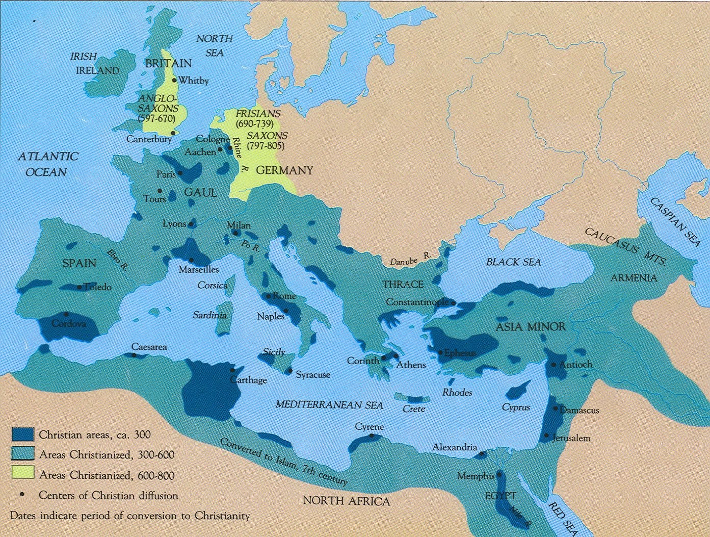
As we said, the Jewish diaspora was concentrated in cities across the Roman Empire, and that’s perfect for viral spread: It’s much easier to convert a lot of people if they’re all together. In a way, the Jewish diaspora enabled many “superspreader events”. This is why the map of Christianity looks like this:

Look first at the dark blue:
Most early conversion was near Israel, where Christianity started
Within its vicinity, it spread mostly in the Eastern Mediterranean (and not Arabia or Mesopotamia) through the Roman highway that was the sea
The farther you went, the smaller the Christianized regions by 325 AD, but always concentrated in cities.
Then, once Christianity was supported by the state, it took over the rest of the empire (light teal).
We saw before how early Christianity probably had many more women than men. Women then converted their husbands and their families, winning political influence for Christianity in the process.
Many women became the first converts in a family, often leading their husbands to conversion but even more so raising their children as Christians. It was often through wives that Christianity penetrated the upper classes of Roman society, with the result that Christians became increasingly influential.—The amazing growth of the early church, Dreyer (2012)
But women were not powerful in the Roman Empire, so how could they make this happen? Peter was specific on the sales pitch:
Wives [...], submit yourselves to your own husbands so that, if any of them do not believe the Word, they may be won over without words by the behavior of their wives, when they see the purity and reverence of your lives.—1 Peter 3
We saw before how social security generated viral growth. If your Christian neighbor is always helping you, you’re more likely to open up to his religion. If your recently-converted sister has a cool group of friends who are always helping her, that’s a club you want to join, too.
So far we’ve seen how Christianity could grow by converting others. But the more it grew, the more the reproduction rate of Christians mattered.
Judaism already had a mandate to be fruitful and reproduce (typical in agricultural societies), which Christianity inherited, but that mandate was not just for Jews, but for all of God’s creatures. Christianity took that to heart and dramatically optimized reproduction. The main way was with a simple philosophical change with massive repercussions: Considering life sacred (because we’re all the children of God). This optimized the reproductive funnel: find stable partner → have sex → conceive → have the baby → keep the baby alive.
The Christian Church famously bans any sex that isn’t vaginal: oral, anal, masturbation. It even bans coitus interruptus, so you can’t have vaginal sex without finishing inside. And of course, any kind of contraception. Basically anything that doesn’t lead to reproduction is banned. Weird, right? It’s a bit of a stretch to go from: Life is sacred to Avoid blow jobs. How did that happen?
What happened with masturbation is an interesting example. It comes from the biblical story of Onan, who was killed by God because he wasted his seed. But the story is misinterpreted:
Onan's crime is often misinterpreted as masturbation, but it is universally agreed among biblical scholars that Onan's death is attributed to his refusal to fulfill his obligation of levirate marriage with Tamar by committing coitus interruptus.
What does that mean? Onan had an older brother, Er, who died without having procreated with his wife. That meant his male line was going to disappear, and that was bad in the patrilineal Jewish culture. So as a younger brother, Onan had a duty called levirate marriage: Have sex with the widow so that she can have children, who will be deemed to be the progeny of Onan’s older brother.
Onan did have sex with her, but he didn’t want her to have a child who would be his brother’s heir (presumably because his other children would not inherit as much), so he didn’t finish inside of his sister-in-law. The problem was in not giving children to his brother, NOT in ”wasting the seed”!
This was the proper interpretation for over 1,000 years, until Christians changed it. Through what process?
Remember that early Christianity was bathing in Greek culture. Aristotle and the Stoics had written centuries earlier that semen had a divine aspect, and that it contained most of what was needed to create a life.
The theologian Clement of Alexandria around 200 AD, and later Augustine around 400 AD,25 put it all together: If God says you have to reproduce, and God said you shouldn’t waste your seed, and semen is divine and contains everything needed for life, then surely all semen should be used for vaginal sex. And Jesus said the bond between a man and a woman is sacred, surely all sex should happen within the marriage, should be vaginal, and geared towards reproduction. Over the following centuries, non-reproductive sex would become more and more vilified.
In the Greek and Roman world, contraception had been common, but Augustine forbade it for the same reason: Sex had to be reproductive. Roman women managed their menstrual cycle to avoid pregnancy and used plants to such an extent that the contraceptive (and abortive) silphium plant went extinct.

If contraceptives failed, abortion was also an option. It was widely practiced in the Greco-Roman world, because they thought fetal development formation was a gradual biological process, not imbued with some sacred meaning. Like a plant or an animal growing. Judaism, meanwhile, discouraged it.
Christians banned it since the beginning.
Thou shalt not procure abortion, nor commit infanticide.—The Didache, ~late 1st or early 2nd century
“If you are delivered of a child before I return home, if it’s a boy, keep it, if it is a girl, expose it.—Hilarion, Roman citizen writing to his pregnant wife.
For Romans, men owned their wives and children, so they could do with them as they wished. That included infanticide, which was a double penalty on fertility.
First, because all the children you kill won’t procreate later.
But second, because of sexism. Romans tended to favor sons, so infanticide of girls was common. The fewer daughters you had vs sons, the fewer potential mothers.
Female infanticide was not an isolated incident: There were ~130-140 males per 100 females in Rome, which suggests about 20% of baby girls were killed!26
Even in large families, more than one daughter was practically never reared.—Lindsay (1968:16), via this
But Jews believed all humans are God’s creatures, so you can’t just kill them like that. Christianity inherited this and banned infanticide, as we just saw in the Didache quote above. That meant more Christian children survived than pagans.
Women who use drugs to bring on an abortion commit murder, and will have to give an account to God for the abortion . . . for we regard the very foetus in the womb as a created being, and therefore an object of God’s care.—Church father Athenagoras, 2nd century
Finally, given the social security service of the Church, Christians received more care than pagans when they were sick. According to Rodney Stark, 30% of pagans died during the plague, but only 10% of Christians!
Adoption was only common among elite pagan classes, but widespread among Christian orphans (e.g. by godparents). That meant many more Christian children survived to adulthood (this is at a time when half of children didn’t reach adulthood).
With all these measures, it’s likely that Christians had many more children, who survived much longer than other Romans’ offspring.
Now that we’ve been growing our Christian groups so much, we need to make sure the bucket doesn’t leak, that there aren’t more people leaving the faith than those arriving. How? Christianity didn’t have the death penalty for apostasy that Judaism (and Zoroastrianism) had, because it was not a state religion. They socially shunned it, but couldn’t forbid it until it was the state religion. So what did they do?
Chrisitianity inherited from Judaism the writing of religious texts and doctrine. Words didn’t easily get corrupted over centuries of repetition. The fact that Christianity communicated so much in writing and had so many gospels made it much easier to bundle teachings in a codex (similar to a book) than the prevailing scrolls. The codex survived for longer and helped communicate and keep a record of all the relevant theology. It also became a symbol of Christianity (the Bible).

Catholicism has many once-in-a-lifetime rites of passage:
Baptism for entry into the group
Confirmation for the passage into adulthood
Marriage for access to sex
Anointing for illness or preparation for death
Burial and mass for after death
All of these require the priest and the community, providing social pressure to stay in the religion. Think about how many people want to get married through the Church even though they’re not believers anymore.
But Christianity bundles all these services together: If you want marriage, you must be baptised, have taken the communion, and be confirmed.
This is not something fully new in Christianity: Rites of passage exist in virtually every religion, Judaism had an equivalent of baptism for men (circumcision), Zoroastrianism had priest-led funerals, etc. Christianity’s innovation was to merge all of these together and make them all social and led by priests. It took it many centuries to get there.
All the rites follow the entire life, but Christianity colonized every year, and every week too: Sunday worship, fasts, feasts, saints’ days, Advent, Lent, Easter, Christmas… It became the rhythm that organized life, and that made it impossible to forget.
One of the best ways to increase retention is suppressing competition, and Christianity’s main weapon for that was…
I’ve mentioned before that Constantine legalized Christianity in 313 AD, when ~10% of the empire’s population was Christian. That share grew tremendously, so that in 380 CE, when Theodosius made it the state’s official religion in the Edict of Thessalonica, about half the population was already Christian.
That takeover allowed Christianity to spread everywhere the empire was present. Remember:
The state takeover brought sticks and carrots.
Before Constantine, becoming Christian could cost you status, safety, and opportunity. The carrot was that, after Constantine, suddenly there was a massive benefit in joining the Church. Confiscated Christian property was restored, bishops gained imperial access, churches received gifts, clergy received privileges, and Christian affiliation became increasingly useful for careers and patronage. The conversion funnel was subsidized.
The stick is that, by co-opting the empire, Christianity became much less tolerant. It latched on to a power that had already been established for nearly a millennium, and repurposed its tools for its own benefit. Starting in the early 300s AD, Roman law gradually:
Condemned sacrifices
Ordered temples to be closed
Destroyed effigies and other sacred items, to show the gods couldn’t defend themselves and demonstrate their humiliation
Defined heresy and opened the door to its suppression
Removed testamentary rights for Christians who become pagan
Forbade public religious debate
Ordered rural temples to be destroyed
Violations of what we would now call human rights and civil liberties were allowed for the sake of religious conformity. In Alexandria in 415 CE, the philosopher and teacher Hypatia was dragged from her carriage, taken to a church, stoned, flayed, ripped to pieces and burned by a gang of Christians, who accused her of witchcraft. Classical learning, literature and philosophy were now all suspect.—Source
[Temple] roofs are uncovered, walls are pulled down, images are carried off, and altars are overturned.—source

Why this change? I don’t know, but I can venture a few guesses.
Early Christians were probably self-selected as the most virtuous people (who else would go against the world preaching love?). Their charisma would carry the crowds.
But there are only so many virtuous people, and once you convert the vast majority of a group, you won’t have only virtuous people. The average hateful guy might say they prioritize love, but might still have the instinct to hate the Others.
If you were downtrodden and suddenly you’re part of a new group where you have status, you’re going to enjoy your new status and be quite aggressive with the former system that kept you down.
Power doesn’t change people, it reveals them. Once you’re in power, you start doing things you didn’t dare to do before.
Aside from sticks (religious coercion) and carrots (advantages for Christians), the other advantage of Constantine becoming Christian is that the religion could start advertising and selling in the open. Before 312, much Christian growth happened through households, urban networks, letters, local communities, and occasional public controversy. After legalization, Christian advocates could preach and debat publicly, build churches, perform imperial ceremonies, produce inscriptions, crosses, music, processions…
One of the biggest concerns of Christianity after it had become the state’s religion was quelling alternative versions—what we call in software forks in the code. There was Gnosticism, Marcionism, and especially Arianism.
That’s one more reason the Church wanted a close cannon, and hence the ecumenical councils or the Bible. Everything that was not approved could be called heresy and quelled.
Joseph Henrich’s book The WEIRDest People in the World suggests that the Church banned cousin marriage in the Middle Ages, among other reasons to undermine clans: If you don’t put your clan first, you’re more likely to put the Church first (or second, only behind the nuclear family).
This would have had the side-effect of reducing congenital diseases and hence improving survival rates27 and reproduction of Catholics,28 bolstering the religion’s success.
Christianity took over the state to use it to grow. But when the state died, it moved on.
As we will see in the next article, most gods were linked to locations and states. If somebody conquered you, it was proof that your god was weak, and that god disappeared. By some unique set of circumstances, Judaism transcended that, and became independent from land and state. Christianity inherited that.
This was very handy when first the tribes of barbarians destroyed the Roman Empire in the west: It was not common for conquerors to completely throw their religion out the window and adopt the religion of the conquered! In fact, the timing couldn’t have been better: The Roman Empire disappeared just as Christianity was reaching its maximum power. When the Barbarians arrived, they killed the state but had no reason to do the same to the Church. Yet the Church had inherited its strong structure and hierarchy from the Roman Empire, so it remained as the most capable structure for power. The Barbarians wanted its legitimacy and efficiency, so they converted and thereby gave the Church immense power. For example, when Rome disappeared, so did its administrators, and hence all schools that taught literacy. The Church still needed literate employees, so it took over all education. And because education was valuable to kings, they employed clergymen, which put the Church at the helm of information power.
We talked about a sales force before, but that was the normal type of sales force, the one that converts small prospects into customers. Enterprise sales tries to get massive companies (“enterprises”) as customers. These require their own elite sales force and a dedicated strategy.
Christianity did just that. It used bishops and other elite clergymen to convert kings into Christianity before the rest of the population. Once the king was Christian, missionaries had a much easier time moving around their lands, harnessing resources, and using the king as the example to follow. This happened with Clovis of the Franks, Vladimir of the Rus, Mieszko of Poland…
It was also very handy to become a power independent from the state. Kings had to obey the Church or risk being excommunicated—something many of them might not have feared personally, but feared because their citizens believed this was terrible. The Church was able to create a system parallel to the state’s, with its own lands, its own leaders, sometimes its own soldiers, its own wars… For centuries, the Church got its own state outright—the Papal States—and they were powerful enough to delay the unity of Germany and Italy by several centuries.
Once states were weak, it was hard for them to settle new land. But monasteries could. The Middle Ages Church would plant a new monastery at the edge of Christian territory (or in an underpopulated area), and bring with it investment: farming, schools, guesthouses, clinics, artisanal industry, manuscript factory… This enabled it to grow its assets and its believers.
Software businesses tend to focus first on growing their audience, and only once they’ve succeeded do they focus on maximizing revenue from their audiences. The Church was no exception. It started with a very promising philosophical base:
You cannot serve both God and money.—Matthew 6:24 and Luke 16:13
Ah, dammit. What does that mean concretely?
It is easier for a camel to go through the eye of a needle than for a rich man to enter the kingdom of God.—Mark 10:25, Matthew 19:24, Luke 18:25
OK so I should not die rich, or otherwise I won’t go to heaven! What should I do with my money then?
If you want to be perfect, go, sell your possessions and give to the poor, and you will have treasure in heaven.—Matthew 19:21
RICH CHRISTIAN: OK, let me do that. But there are a lot of poor people, how do I know who to help?
THE CHURCH: Don’t worry, give it to me, I’ll take care of it.29
So that meant bequests were a primary way for the Church to get a lot of money. Here, we can see how some other factors from earlier matter. There was much less pressure for women to marry, and especially for widows to remarry. If they died with a fortune but no children, where did that fortune go? To the Church.
If clans had been strong, they would have been the primary recipient of the money. In fact, in clans, property is not as much part of the individual as it’s part of the clan. By eliminating clans, the Church co-opted more bequests.
These donations were unidirectional: The Church kept most of these assets and made money out of them. The more it accumulated, the more money it made. Back then, wealth meant land, and the Church became the biggest landholder in Europe in the Middle Ages. The Church hired farmers to produce wealth from these lands. It also owned other types of infrastructure that it monetized: granaries, mills, bridges…
Also, remember that the Church ensured asset accumulation by preventing clerics from having children.
But they weren’t the only source of income. Early on, the Church received some income through charity, but once it was part of the state, it received tax benefits and direct transfers from the state. Eventually, the tithe (one tenth of people’s income) would become mandatory for all. This is substantially better than the episodic payments that polytheist temples received. On top of that, the Church received fees for sacraments and burials, relic-based pilgrimages, monastic enterprises (wine, wool, brewing), the sale of indulgences, papal taxation of clergy…
Like Facebook and Google showing too many ads, the Church overplayed its monetization hand, and people started defecting. The sale of indulgences was the proximate trigger of the Reformation.
It’s impossible to cover them all, but here are a few:
The Church invests heavily in education, financing it for many people to this day. That allows it to insert Christian education, through which people are retained and converted.
The anti-forking software I mentioned before also included things like the Inquisition. But also, Jesus didn’t have a doctrine against new branches of Christianity.30 So once the Church lost its monopoly on information, many versions of Christianity appeared. These compete with each other, allowing for the most efficient ones to prevail. It meant lots of wars early on, but also many more approaches today.
Christianity also spread through crusades. The ones we know the most about are actually the failed ones in the Levant. There were many successful ones in other parts, such as the Baltic Crusades and the Spanish Reconquista.
This breakdown of the Christian Church’s business tactics is not exhaustive, but even then, you can see how it came up with ~100 innovative mechanisms for growth.
In some cases, these mechanisms came from Judaism, such as:
The monotheism
The deterritorialization that allowed Christianity to survive the state
The tendency to write everything down (which allowed for more retention of the content, more spread of doctrine, and reducing forks due to misinterpretation)
The benefit of target populations in urban areas spread around the Mediterranean, ripe for conversion
Others emerged from new religious doctrine:
From the concept of “There is neither Jew nor Greek, there is neither slave nor free, there is no male and female, for you are all one in Christ Jesus” came a huge TAM that included gentiles (especially the Jewish-adjacent), appealed to women and the poor, a missionary sales force, viral spread through each believer, the elimination of circumcision and food restrictions, made homes into temples… But remember, this did not come from Jesus!
That phrasing of “in Christ Jesus”, plus the concept of love, entail the ideas that all humans are sacred, which led to tactics of anti-contraceptives, anti-abortion, anti-infanticide, care for the sick, orphan support, higher survival rates, social security services, enabled traveling healers… It formed the core of the value proposition of loving yourself and your neighbor.
If you adopt faith as a virtue, you reduce your skepticism, you are more open to new doctrines, you’re more likely to advertise the religion through martyrdom…
If salvation becomes super high stakes, legible, and actionable, you suddenly have a massive incentive to do what’s right for the community
Yet others were a result of the Roman Empire:
The early multilingual nature of Christianity
The unified market of the Roman Empire, enabled by the Mediterranean highway and Rome’s famous roads
The ability to evangelize in big cities across the empire, which acted as superspreader sites
The ability to harness the power of the state to spread
The Roman Empire also provided the administrative structure the Church adopted
Some are a combination of these, like for example, the success of Christianity with women is a combination of making women more equal and the terrible treatment they received in antiquity.
And many others are completely untethered to any of these, including:
Many of the monetization tactics
Kin suppression
Anti-forking software
Destruction of alternative temples
Making priests celibate
How can we summarize all of this?
Judaism had many compelling aspects to become a huge religion (monotheism, deterritorialization, heaven and hell…), but was missing a few key levers.
There were many prophets within Judaism who proposed variants, but the one Jesus invented was the most fit for growth, thanks to a few concepts: all are one in God, love each other, have faith. They unshackled Judaism’s software barriers to growth.
But Judaism lacked network infrastructure. When the Roman Empire conquered Judea (just 60 years before Jesus was born!), it brought the infrastructure needed for the massive spread of Judaism’s successor religion.
Jesus’s followers were deft enough to continue changing and adapting Christianity (or even inventing new concepts altogether) to optimize growth. The optimization was ruthless and lasted more than a thousand years.
I talk a lot about Christianity being designed in this article, but I don’t always mean it as purposeful design, as… intelligent design. A potential process was more like… evolution: Judaism was a new religious species that had evolved from others, the Roman Empire provided a new environment, lots of religious variety emerged from that, natural selection meant the fittest one—Christianity—exploded… and as it became an institution, it started being managed as such.
But as we saw, many of the changes didn’t happen at the time of Jesus, but after his death. It would be surprising if all of Christianity’s mutations happened so fast, and always coincidentally geared towards growth. It’s as if it had been helped by some enterprising human hands.
Or maybe God’s purposeful hand.
I’m opening the newsletter to sponsorship. If you have a business that is moving the world towards a techno-optimistic future and would like to reach 125k+ curious, globally-minded people to learn about it (founders, researchers, investors, policymakers), reach out here.
My confidence on that statement is 60%. There are other books who cover the topic (I’ll share details on each below) but I don’t think any covers the topic as exhaustively from a growth perspective:
Very few works focus on Christianity as a software mechanism. They tend to focus on the story, and narrate the growth, rather than understanding the actual growth mechanics at play. I think this is sensible: The people who write about this topic tend to be historians or theologicians, not people who have actually designed viral software products—which I have.
Many of the sources I’ve read mention these other books, but they frequently point at holes or flaws in their pages.
That said, I have not read these books personally, so the information that reached me through them might be too limited, and they indeed covered everything.
To clarify, I asked ChatGPT to compare this article’s additions to those of other books, and it sees many contributions from different books, but none that covers them all (plus, some novel additions, like the feeling of progress).
One key additional point here is that I purposefully didn’t cover the advantages that Christianity had compared to the Roman polytheism because I don’t think these are Christianity’s contributions, but Judaism’s. I cover them in the next article.
Below I have a short summary of each book on the topic, and the take from ChatGPT.
The Oxford Handbook of Early Christian Studies is a 1,000+ page interdisciplinary reference on early Christianity, covering history, literature, thought, practices, material culture, church/empire, women/gender, councils, canons, and geography. As such, it doesn’t focus only on growth mechanics, and it doesn’t either see many of the changes of the early Church through the lens of growth.
Ramsay MacMullen’s Christianizing the Roman Empire: A.D. 100–400 does focus on growth, but is limited to the years 100-400 AD, and is very focused on the state- asks how Christianity gained dominance in the Roman world, with sections on Constantine, nonreligious conversion factors, public campaigns, intellectual conversion, incomplete conversion, and coercion.
Alan Kreider’s The Patient Ferment of the Early Church is another direct competitor on early Christian growth, asking why the church grew despite disincentives, harassment, and occasional persecution, but according to ChatGPT it missed many mechanics. I didn’t stumble upon very frequently with quotes of it.
The two biggest competitors are Bart Ehrman’s The Triumph of Christianity and Rodney Stark’s The Rise of Christianity. I’ve seen them quoted in many of my sources. Both cover many of Christianity’s aspects, but not all.
This is illustrated by this video.
First by emperor Constantine, who made Christianity legal in 313 AD, and then by Theodosius, who made it the state’s religion in 380 AD
I calculated the number based on the data, which comes mostly from Stark’s The Rise of Christianity, 1996.
We can divide the growth into 4 phases: Between JC and becoming an official religion of the Roman Empire, Christianity as the empire’s religion, the Middle Ages until ~1500, and then the hypergrowth during the Age of Discovery and the Industrial Revolution. I’ve focused mostly on the first two, and especially early Christianity, because that’s when its success was shaped. But I cover up to the Middle Ages, since many innovations only came later but are still relevant to helping us see the patterns it followed. Christianity’s growth after that is more straightforward: It was the religion of the countries that eventually won the Age of Discovery and the Industrial Revolution. Christianity might have had a hand in these, but it was also a tool that hindered them, so I decided not to cover that period here.
The theological version is that some angels / God appeared to a Roman centurion (pagan). At the same time, Apostle Peter had a vision where God told him to kill and eat all sorts of animals, not only the ones Judaism considered pure. When Peter said no, a voice told him three times “Do not call anything impure that God has made clean”. He then saw the centurion, put two and two together, understood that the message meant “It’s not just the Jews that are part of Christianity, also others”, and that became the most compelling argument such that, later in 50 AD, Christians decided to open up to all peoples at the Council of Jerusalem.
Via The amazing growth of the early church, Dreyer, 2012
In a big part because they're more susceptible to peer pressure than men.
There is some debate about whether this is fully true, but from the evidence I’ve seen, I think it’s 80% likely that women were at least 5 to 10% more common than men in the early Christian Church.
Things like What is the ultimate reality behind the world? Is it matter, atoms, Forms, the Good, the One, Nous, Logos, divine fire? Christianity said: one transcendent Creator, God. Or Why is the universe ordered and intelligible? Divine reason? Logos? Forms? A demiurge? Christians saw the divine reason of God. Or What is the good life? Flourishing, happiness, blessedness, the highest good? Christians said: True happiness is union with God. Virtue matters, but it is completed by grace, love, worship, and salvation. Other questions include: Why does evil exist? Are we ruled by fate, chance, or providence? How do we know truth? What happens after death?
There’s an interesting hypothesis too that the most likely Christians to be martyred were women and clergy, which is interesting because they tend to inspire more compassion than men.
The amazing growth of the early church, Dreyer (2012)
Even if these things had been true.
I’m named after him, I’m sure you’re not surprised.
Monks were celibate since early on, 3rd century or so. For priests, it started around then, but only became fully enforceable around 1100 AD.
That sentence beginning “There is neither Jew nor Greek…” was said by an apostle, and another apostle was proselytizing to gentiles when he said he got a visit from the Holy Spirit, validating the entire approach of converting gentiles.
It was not immediate though. For example, baptism took years of preparation early on. It was simplified over time, presumably to accelerate the speed of conversion.
This one is kind of crazy to me. Isn’t it surprising that Christianity has one God that is in fact three, and then has Mary who is not a goddess at all, and yet is incredibly revered? In this case, I reckon sometimes this switch was purposefully designed, others it just happened naturally.
A church to Cosmas and Damian was built in Rome near the old forum in the 6th century.
Buddhism also took over deities from Hinduism as it spread. They became devas and protector figures (Indra, Brahmā, Bishamonten, Emma). Bodhisattvas appeared in Buddhism to fulfill the same functionality as a saint in Christianity. In Japan, Buddhism merged into the local animist ideas to form honji suijaku: Buddhist deities became Japanese Kami. Later, in the Meiji Restoration era, elites extracted Buddhist concepts from the local Shintoism, but merged it with monotheistic ideas, elevating the goddess Amaterasu to the chief God, and making the emperor her successor, therefore making him a god too.
This change happened in the 300s AD. Another theory is that early Christians might have thought that Jesus was conceived the same date as he died (March 25th), so 9 months later is December 25th. This sounds very dubious to me, because (1) early Christians didn’t care at all about birthdays, and (2), how on Earth would they come up with that conception date? This sounds to me like retrofitting the conception to the target, which had to be December 25th for the other reason.
That said, this probably didn’t happen just after Jesus’s death, as the apostles were doing most of the missionary work. This is one of the key points made by Alan Kreider in his book The Patient Ferment of the Early Church.
Before, all sex was OK within marriage. It’s interesting to understand why Augustine reached this conclusion. He was Bishop of Hippo (today in Algeria) and a former sex-addict who had to give up a mistress and casual sex to marry an heiress. Faced with the requirement to limit sex to only his wife, he decided to stop his lust by not having sex altogether—hence why he became a bishop. Then, he coupled the Biblical concepts such as being fruitful and the sin of Onan to recommend that all sex be reproductive. The ultimate consequence of that was, indeed, more reproduction.
There are 105 boys per 100 girls born in general, so 130 boys should have produced 124 girls. 24 girls are missing from those 124, that’s 20%.
And IQ.
This is disputed. The main argument against it is that some Catholic areas already didn’t have cousin marriage before the Church mandated its end.
Very convenient
Unlike in Islam
2026-06-14 15:42:03
Uncharted Territories is growing. I want to make it better in all dimensions, and a key one is visuals and user experience. I obsess about it, but I’m not a designer, so I’m looking for the best ones to make Uncharted Territories products both incredibly usable and stunningly inspiring. If you are a designer or know one, I want to share two ways in which you can help do that: Work with us full time, or make designs for our merchandise shop.
You might not want to work for us full time, or you’re more on the graphic side of design? Perfect! We’re building a shop for Uncharted Territories merchandise, and we want to fill it with some of the best items you can find anywhere. That means we need designs, and the best ones will probably come from you, the people who know Uncharted Territories the best.
Every week, I spend hours reworking graphs and generating compelling images to illustrate the ideas I’m writing about.

Humans have absorbed visual information for millions of years, but we’ve been reading for just a few thousand. We’re much better at understanding through visuals than words. The right visual can make a complex idea instantly clear. My challenge each week is to take real information and make it stimulating, exciting, and accessible.
Today, I pass that challenge on to you. I’d love for you to take an idea from Uncharted Territories and turn it into a poster. Something that will reframe how people understand how the world works, that is at the same time so beautiful and inspiring that people will want to hang it on their wall.
For that, you have two ways to participate: a competition, or an application.
The brief is simple: Design a poster based on Uncharted Territories that would be a talking piece in any room.
I’m offering a $1,000 grand prize to the image that best conveys a map, chart, idea, or full article in an interesting and visually stunning way. The best examples will tell a story that will have visitors staring at it and asking where it’s from.
Specs
$1,000 prize, open to everyone worldwide
Submit as many entries as you like
Choose any UT article, map, or idea as your subject
A2 / 18×24", submit a screen-resolution preview: JPG or PNG, max 10 MB
All entries will be displayed publicly, unless you opt out
I will select the winner, heavily based on community opinion
Deadline: 22 July 2026, winner announced 5 August
Submit your best design via the Competition landing page. The winning entry will receive $1,000 cash, with their poster becoming the flagship product in a new Uncharted Territories shop.
Public commentary will be open for the length of the competition and for two weeks beyond. I’ll highlight a few of the most immediately impressive pieces in the newsletter and on socials as the competition runs, with credit given to their creators.
Viewers can like and comment on their favorites but the final say will be mine. I want to know which designs resonate but I don’t want it to be a popularity contest.
The competition isn’t only for current readers. If you know any designers who you think would be good at this kind of visual storytelling, please forward them this article or the Competition homepage. All IP stays with the designer for artworks I don’t end up using.

Then I’ll pay for the others too!
I’m not saying I’ll only pay $1,000 for one poster. I’m saying I’ll pay at least $1,000 for one poster. But if we have lots of amazing posters, and we’d like to put them all on the site, I’ll happily pay for more posters!
Not everybody can spend time working on a poster without a guaranteed payment. I get it. So beyond the competition, I’d like to commission designs for use in Uncharted Territories posters and merchandising.
Simply head to the competition page, scroll to the Direct Applications section, and tell me why you think we should work together: Maybe that means your portfolio and your ideas for what you’d like to do for Uncharted Territories, maybe something else.
I’m really excited to see what you come up with!
I’m building a small team of developers: With AI, I think just three are enough to build incredible tools. I’ve already hired our first vibe-coder / engineer, and we’re building so fast you’re soon going to see amazing products. But neither of us are designers, so we’re looking for our second vibe-coder—a person who can complement our skillsets, so I’d like this person to come from the world of design.
So if you:
Have experience as a UX/UI designer
Have great aesthetic taste and a strong sense of what’s usable
Love the Uncharted Territories asesthetic, but want to make it 10x better
Have jumped into the world of AI and have been vibe-coding your own apps
Then go to this page and join the expedition!
Know somebody who could fit the description? Send them this page!
2026-06-09 21:03:03
This timely article is probably the hardest, most important one I’ve written this year—maybe in years. I might not get it all right, so I look forward to your comments and corrections. If you believe it can help heal society, please share it.
“Muslims are violent and try to impose their beliefs on others! We should send them all back to their countries!”
“That’s just islamophobia! You’re a bigot!”
Both of these are not just wrong: They’re blurring concepts of freedom, equality, immigration, race, and politics at such a fundamental level that they’re threatening the foundations of our society. Today, we’re going to try to make sense of it all. By the time you’re done, you should be able to see a conflict related to Islam in the West on the TV, on social media, or on the street, and have a better sense of what we should do about it and why.
At the heart of this is the mixing of two concepts: Islam and Islamism.
Islam is a religion followed by 2 billion people in the world, ~25% of the population. It is a personal belief, protected by the Universal Declaration of Human Rights. Like in most religions, most adherents of Islam are kind, welcoming, peaceful, and productive. You can witness it yourself traveling to places like Turkey, the UAE, Malaysia, and Indonesia, where this was certainly my experience.

Islam has over 1,300 years of history, and has produced some of the most distinguishable aesthetics.

Its position in between the biggest world civilizations allowed it to preserve knowledge from older empires, increase the exchange of knowledge across civilizations, and produce fundamental new contributions.
But within Islam, there’s a problem of Islamism: a political movement that says Islam should influence politics because it’s superior to liberal democracy, capitalism, and any other alternative. Islamists want Sharia (the law derived from Islam1) above civil law, they want it to apply to non-Muslims, they seek pan-Islamic political unity, and the creation of Islamic states. So by nature, it’s not individual and persuasive, but social and coercive in its attempts to spread. That’s why the European Court of Human Rights declared Sharia incompatible with the fundamental principles of democracy. It’s why Turkey banned the leading political party in the late 1990s: Its Islamism went against democracy and the country’s secular constitution.
There is a blurry line between Islam and Islamism. It’s crucial to understand it though, so let’s take specific examples.
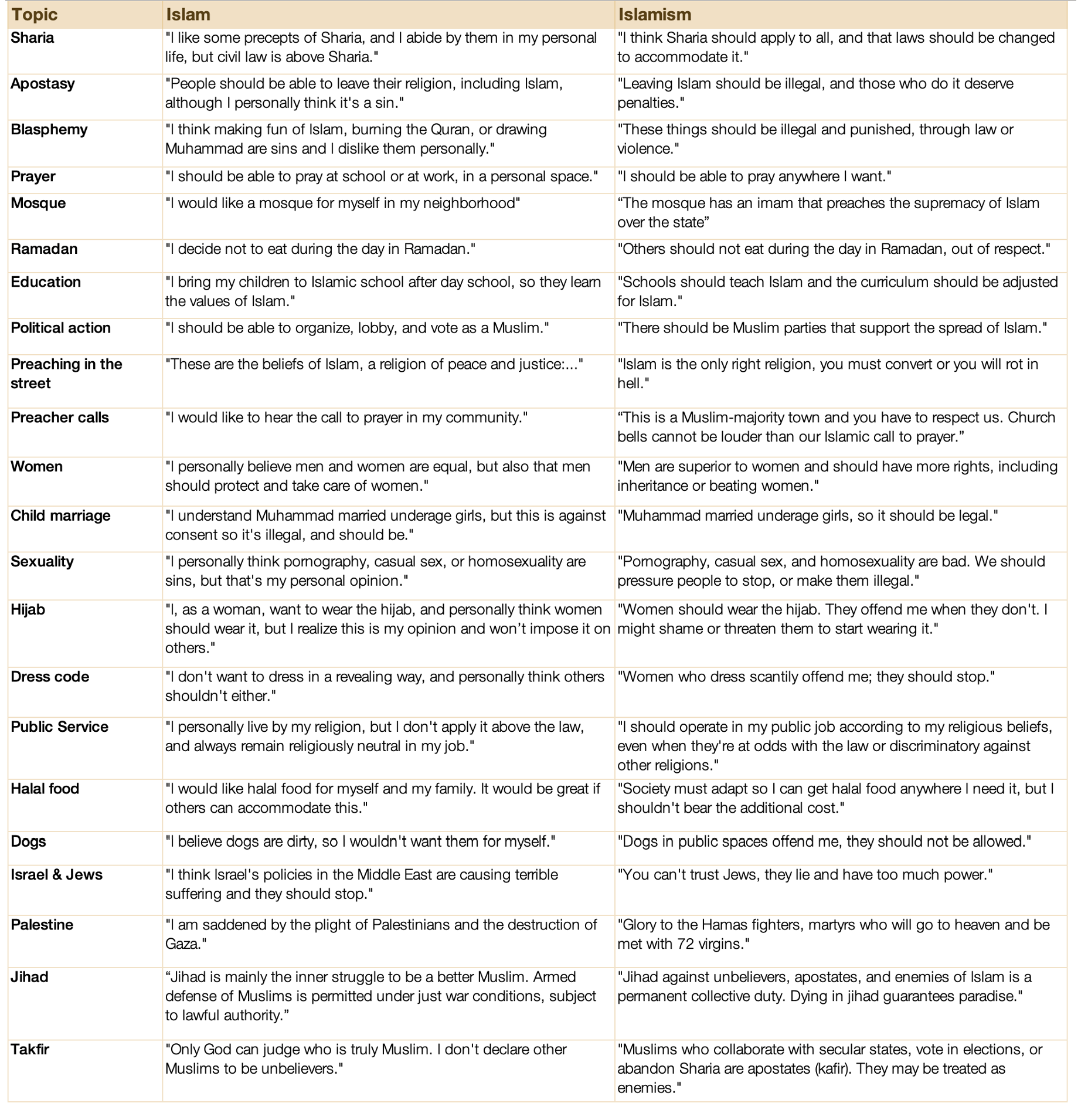
I hope the difference is clear: Islam whispers to the soul; Islamism shouts on the street. Islam wants believers to get on their knees, Islamism wants you to get on yours. Islam breeds pilgrims, Islamism conquerors. Islam saves souls, Islamism drafts laws. Islam wants the freedom to believe, Islamism wants obedience.
Islam is a personal religion, a set of personal beliefs. Moderate Muslims respect that others don’t share the same beliefs. This is protected by the Universal Human Rights. Islamism is a political movement that tries to impose its views on others. This is against Universal Human Rights.2
Islam is protected by Universal Human Rights, Islamism is against them.
If you want a test to differentiate between Islam and Islamism, here are seven questions you can ask:
Is it voluntary or coerced? If it’s voluntary, it’s consistent3 with Islam. If it’s coerced, it’s consistent with Islamism.
Is it just for the believer (consistent with Islam), or also for others (consistent with Islamism)?
Is civil law supreme (Islam), or is Sharia (Islamism)?
Are all citizens equal (Islam), or do Muslims prevail (Islamism)?
Is it persuasion (Islam) or intimidation (Islamism)?
Does it make room for dissenters inside the community (Islam) or not (Islamism)?
Is the same standard applied to all religions (Islam), or does Islam have privileges (Islamism)?
Now, these are extremes. As we saw in this article, in the West:
About 20 – 50% of Muslims are moderate Muslims
About 15-20% are Islamists
In between, about 10-50% are Conservative Muslims. They might, for example, think that the precepts of Islam should apply to all, but they might use persuasion instead of coercion to achieve this goal.
If we were to draw this:
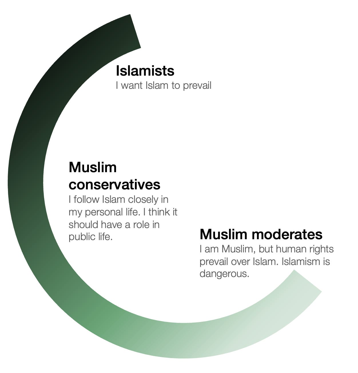
The best way to understand the difference between each extreme is to dive into each separately.
They believe in Islam, and they also tend to think that:4
The Quran is not the literal word of God
There are many ways to interpret Islam
Democracy is above Islam, and they’re compatible
Men and women are equal
Homosexuality should be accepted in society
Jews don’t have too much power, they can be trusted
Israel has a right to exist
School should be secular and mixed genders
It should be legal to show a picture of Muhammad and burn the Quran
Halal food is not necessary everywhere
If you’re a Westerner and you know Muslims, odds are higher that they belong to this group. That’s been my experience: I’ve had friends and colleagues from Morocco, Algeria, Tunisia, Egypt, Saudi Arabia, Turkey, Iran, Pakistan, Iraq, and probably more that I can’t remember, and every single one of them was kind, fun, tolerant, and hard-working.
These Muslims know and understand the threat posed by Islamism. They think:
Islamism is a problem
Political violence is never acceptable
Jihad in general, and organizations like ISIS, Hamas, Hezbollah, or the Muslim Brotherhood are bad
Moderate Muslims would want nothing more than the elimination of Islamism.
This goes to the highest levels of several Muslim countries. For example, Saudi Arabia, Jordan, Egypt, the UAE, Kazakhstan, Tajikistan, and Libya have all outlawed the Muslim Brotherhood, in most cases designated it a terrorist organization.5 Many prolific Arab commentators agree.
Here is Mohamed Bin Salman, ruler of Saudi Arabia, about Islamism:
We want to go back to what we were, the moderate Islam that is open to the world, open to all the religions. We want to live a normal life. We represent the moderate teachings of Islam and the right is on our side. We will eradicate the rest of extremism very soon.
Here is the UAE’s Foreign Minister in 2017, talking about Islamism in Europe (a bunch of additional quotes follow. If you get the gist, you can move on):
There will come one day when we’ll see far more radical extremists, and terrorists, coming from Europe, because of lack of decision-making, trying to be politically correct, or assuming that they know the Middle East, or they know Islam far better than we do. That’s pure ignorance.
Mosab Hassan Yousef, son of a Hamas founder, was so repelled by the organization that he defected to Israel, and later to the US, and has been criticizing it ever since. Saudi Arabia, Egypt, and Jordan have banned the organization.
Here is the a Lebanese Shia Muslim preacher:6
We need to review Islam from beginning to end. The human being no longer has value in this religion. You [Islamists] have distorted the true image of Islam. You have made us feel that Islam is only gunpowder, rockets, killing, and crime. There is the silence of one and a half billion Muslims across the globe. Silent about all this destruction. Silent about the massacres. Silent about killing in the name of God. Every crime committed is being accompanied by the slogan “Allahu akbar.” We can no longer leave Islam as a playground for these so-called Islamists, these criminals, these terrorists.
The whole world has come to hate Islam and Muslims. Campaigns of hatred against Muslims and Islam are rising because of the behavior of Muslims, and because of the behavior of Islamic leaders who remain silent about crimes and justify them. How is the far-right Christian movement rising in Europe? Because it has become afraid of you as a Muslim. What are you offering to break this stereotype? What are you offering so you can say to him: “No, that isn’t true”?
All our calls are calls to violence. All our calls are calls to killing. All our calls are calls to exclusion and eradication. I do not feel peace. I want to feel peace. There has to be a corrective movement in the Islamic world. I want the Islam that came and opened this message with: “In the name of God, the Most Merciful, the Most Compassionate.”
We Arabs from the Arabian Peninsula and the Gulf the original heart of Islam don’t tolerate extremists in our countries. Our societies are genuinely tolerant. We welcome people from all backgrounds whether they’re different in race or religion.
The real hardliners and extremists run away from our region and head straight to Europe, America, Japan, & places like that. They take advantage of your freedom of speech in the worst way possible and try to tear down your customs, your culture, & your way of life. Sadly, you keep giving them that space & then later you blame Islam for the mess.
Here is the Emirati commentator AQ Almenhali:
A friend of mine travelled to the West recently and went to pray at a mosque there. He told me the [sermon] started normal, then slowly became political and started talking about jihad. He literally said: “I can see how people here get radicalized hearing this stuff.” He got up and left halfway through.
This is exactly why the UAE and other GCC countries regulate mosques through Ministries of Awqaf. It’s not about “controlling religion”, it’s about stopping religious spaces from turning into political recruitment centers.
The Muslim Brotherhood mastered this years ago: mix religion with politics, build grievance narratives, then slowly create ideological loyalty.
The West keeps viewing this as “freedom of speech”. Gulf countries view it as national security.
And Amjad Taha, Emirati expert in Middle East politics:
Why does Britain today have more extremists than the Middle East, and more rapists rivaling the Islamists of Port Sudan in Africa and Pakistan? And why does the UK system protect Islamist jihadist thugs and rapists instead of protecting its own people? We fear visiting London, it is no longer safe. Your people deserve better. Your streets are crowded with 300,000 homeless in London alone, yet while poverty grows, the Muslim Brotherhood, banned in the UAE and Saudi Arabia, is free to run your streets.
Here is the Gazan Arab Muslim Ahmed Fouad Alkhatib:
The "pro-Palestine” movement refused to acknowledge the criminality of hostage-taking & killing innocent Israeli civilians, condemn Hamas’s actions including against Gazans, call for the terror group to step down, or engage in pragmatic activism and targeted demands for specific outcomes that actually help Palestinians [... It] will forever be looked at as the pinnacle of embarrassment, failure, and wasted opportunities—all while the people of Gaza suffer horrendously.
Maliq, another Muslim commentator:
Truth be told: The #1 cause of Islamophobia isn't outsiders. It's us Muslims. Our resistance to reform, silence on extremism, and victim mentality. If we fix ourselves, the fear will fade.
And:
One thing I absolutely hate about us Muslims is our dishonesty. ISIS, Taliban, Boko Haram, they name their groups "Jihad" and "Sunnah", wave the Quran, scream "Allahu Akbar" during attacks, force hijabs on captives, and forcibly convert people at gunpoint. Yet we still rush to say "They're not real Muslims!" Bro, we can say they don't represent Islam. That's fair debate. But pretending they have zero connection to the faith while they quote our books and use our slogans? That's pure denial. We can't keep lying to ourselves and the world forever. The truth isn't Islamophobia. It's honesty.
UAE commentator Majed, on the rapes of several thousands girls for decades in the UK, in what’s called the Grooming Gangs scandal, of which allegedly7 a majority of perpetrators were Pakistani men and a majority of victims White British:8
To imprison a 13-year-old girl, drug her, and abuse her for profit is pure evil. Predators like this do not deserve the name of men. They are monsters who prey on the innocent. What’s even more shocking is the so-called “justice” in the UK. Six years? Nine years? A child’s life has been shattered forever, yet these criminals will walk free while their victim is still young. If this happened in our region, the punishment would have been swift and merciless.
Another take:
I hope this gives you a good grasp here: There are many moderate Muslims—20% to 50% of Muslims in the West, as I mentioned.9
And many moderate Muslims very publicly decry the radical Islam speech and behaviors that have been festering, especially in Western countries. How is this happening? Who are these Islamists? What do they say?
In the previous article, we saw that about 15% of Muslim immigrants in Europe are Islamists.10 What does that mean?
The best way to understand Islamism is through the eyes of the imams who preach it.
Here’s a cut of some imams in the US
These are examples of Islamic viewpoints that are consistent with human rights:
The goal is to make sure Islam is well established in society. To integrate Islam in the USA.
You dedicate yourself to establish justice in the world. That’s what Allah created you for.
Allah mentions he has sent the prophets to establish justice on Earth.
Allah teaches us that there is one purpose: Establishing justice on Earth.11
I haven’t sampled mosques, but I assume this type of message to be the majority. The following are Islamist though, inconsistent with human rights:
We’re supposed to bring Islam to regulate society according to divine law and purpose.
Allah made it obligatory upon the Muslims to change society.
You need to completely replace the system with an Islamic system.
When we say America will be an Islamic country some day, that’s our goal.
Islam has a second round, where Islam will rule the world again.
Here are some other examples of imams sharing Islamist positions in the West:
California: “Islam will enter every household in the US.”
California (San Diego): “America will be a Muslim country, Russia will be a Muslim country. We have to be part of that change. Never apologize, never compromise.”
Again San Diego: “We must understand Islam as a comprehensive way of life, which includes political influence. In Medina, at the beginning, Muslims were a minority. For some it took weeks, months, years to accept Islam, but Muhammad taught us how to build that power.”
Texas: “Mamdani as the mayor of New York is a victory for the Ummah, and if you don’t understand this, you don’t understand the role of civilizational strength. Everyone has a role to play. (Muslim) politicians have a role to play. [...] Across the Western world, Muslims are rising to the point it’s terrifying them. Sweden, Oslo, 10% Muslim. Vienna is 10% Muslim, the Ottomans Turks tried for 200 years and couldn’t do it.”
Colorado: “We’re still fighting Jihad, just not with swords.”
Detroit: “For Muslims, it’s an obligation to prepare against your enemies. The first obstacle is the Wordly life: When you are too attached to it, you’re not prepared to sacrifice. They say ‘You’re too few, just 1%, you can’t do anything, overpower the military.’ But how many times have small groups of dedicated believers overcome groups far more powerful than them?”
UK: “The first blow to the US was Afghanistan. Now we can give our final blow to America. It’s the opportunity to project Islam as an alternative world order. Now is the time to put the final nail in the coffin of Western liberalism.”
UK: "No integration, no multiculturalism, no diversity, no tolerance. You have democracy, we have Sharia."
England, UK: “We (Muslims) have to be Allah’s solution to England.”
Northampton mosque (UK):12 “Victory to Islam. Destroy the enemies. Bless the Mujahideen (holy warriors). Heal from the usurping Jews and every enemy of Allah. Count them and kill them, leave none of them alive. Make them war booty for the Muslims.”
Dublin (Ireland): “Many of the major problems in the Western world today are because women do not know the status of men in Islam. Since we live in the Western world, women prefer to think that men are equal to them. In Islam, the man is the master of the woman, and the woman obeys the man. The man is the master of the woman. A woman should not raise her voice against her husband. A woman should not leave her house without her husband’s permission.
Germany:13 “Is it permissible to stone someone for adultery? Yes. Obviously, here in Germany you cannot stone someone for adultery. But if there were an Islamic state, then it would be the duty of its ruler to enforce these rulings of the Quran."
More here, here, here, here, here, here,14 here, here, here, here, and here.
Why is this Islamist rhetoric so widespread? Among other things, because it’s politically pushed in the West by Islamist organizations like the Muslim Brotherhood (MB).
The UAE, France, the UK, Spain, and Austria have recently published reports on how it’s organized and how it pushes Islamism by penetrating all levels of society from the bottom.15

It avoids using its own name in the West, keeps membership secret, establishes front organizations and umbrella groups.16 It builds parallel societal structures like schools, nurseries, or funeral homes. In France, it operates over 60 schools. It trains imams across Europe and organizes activities for children. It promotes political candidates in national and local elections and actively lobbies police.
It actively isolates Muslims in the West to preserve its ultra-orthodox views. It created an organization17 to issue religious rulings specifically tailored to Muslims living in Europe, which often promote segregation, discourage assimilation, and push a literature of victimhood of Western societies.
It funds itself with tens of millions of dollars.18 Its biggest donor is Qatar.19 It also has a network of NGOs that host large-scale fundraising events, concerts, and dinners that attract Muslims far beyond their base, thereby expanding their influence, and gather the Zakat (charity). In the UK, charities have found to be important infrastructure for the MB and the terrorist group Hamas. The MB also engages with politicians to secure public funding.20
The proliferation of Islamist speech in Western countries, enabled by these Islamist organizations, is one21 of the reasons why, in some of these countries, next-generation Muslims are actually more radical and more Islamist than their parents.
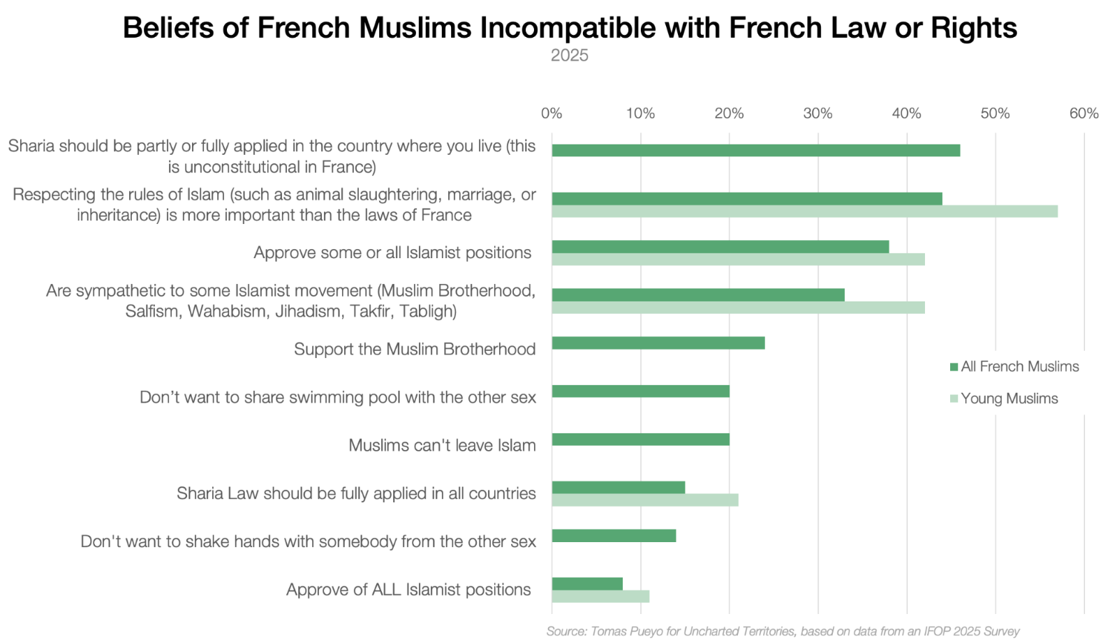
This, then, finds its way into Western politics.
Elected officials in Belgium intended to implement aspects of Sharia Law in the country. This is very direct Islamism in action.
Chaudhry Sarwar, former Pakistani politician,22 previously UK MP for the Labour party, and father of the current Scottish leader of the Labour Party, stated: “Time will come that there will be a law all over the world that there can be no disrespect to our beloved holy prophet. Any disrespect of the Quran will be inacceptable, intolerable.”
Here is Zul Mohammed, a Muslim who ran for Mayor of Carrollton, Texas:
No vet has made any sacrifice. I want to make that clear. I do not support the US military. No, I do not support the United States. I look down on both entities.
These are politicians!
Unsurprisingly, the head of the German domestic intelligence agency has warned that Islamists were deliberately trying to influence German parties to change the state and society.
Obviously, this trickles into education. In Canada, 11 teachers of North African descent were suspended for teaching “Islamist religious concepts” to elementary school children.
It bleeds into political rallies, like this one in NY:
There is nothing more glorious than a martyr. The Western world is a lie. The members of Congress will be prosecuted, all over the world. Let’s remind the mainstream media that Goebbels was going to stand trial before he shot himself, and we intend to prosecute every media outlet.
And it bleeds into interviews of the public, like this one:
We’re not here to take part, we’re here to take over.
Or this one:
We’re here to take over your country. You can’t stop us. We’re here to uphold Sharia Law.
Or this one:
“As a Muslim, I don’t really identify with British values. I’m Muslim first, second, and last. I’d like to see Britain governed by the Sharia. I believe it’s far superior to democracy.”
Or this one:
INTERVIEWER: Would you undermine the German constitution if you could?MUSLIM INTERVIEWEE: Absolutely. We are commanded to take over Germany.
INTERVIEWER: How do you intend to establish Sharia here and create an Islamic state?
MUSLIM INTERVIEWEE: When Muslims are the majority, and if needed, by force.
Or this example, which I shared in my previous article:
INTERVIEWER: How satisfied are you in Germany?
MUSLIM INTERVIEWEE: Zero. Mainz [German city] belongs to us foreigners.
INTERVIEWER: Would you fight for Germany?
MUSLIM INTERVIEWEE: I wouldn’t do anything for Germany. Just marry a German woman, get a German passport, and I’m all set. [...] I’m from Kurdistan. I have no country, They can’t deport me. [...] Germans out, foreigners in.
You can see more examples here and here. You get the picture.
All of this is speech, and if it remained as such, it would be OK. But it doesn’t.
The worst, of course, is terrorism, which we discussed here.
Over 80% of terrorist attacks in the world are carried out by Islamists—groups like Islamic State, Al-Shabaab, Hamas, JNIM23, etc.
This is also true in the West.
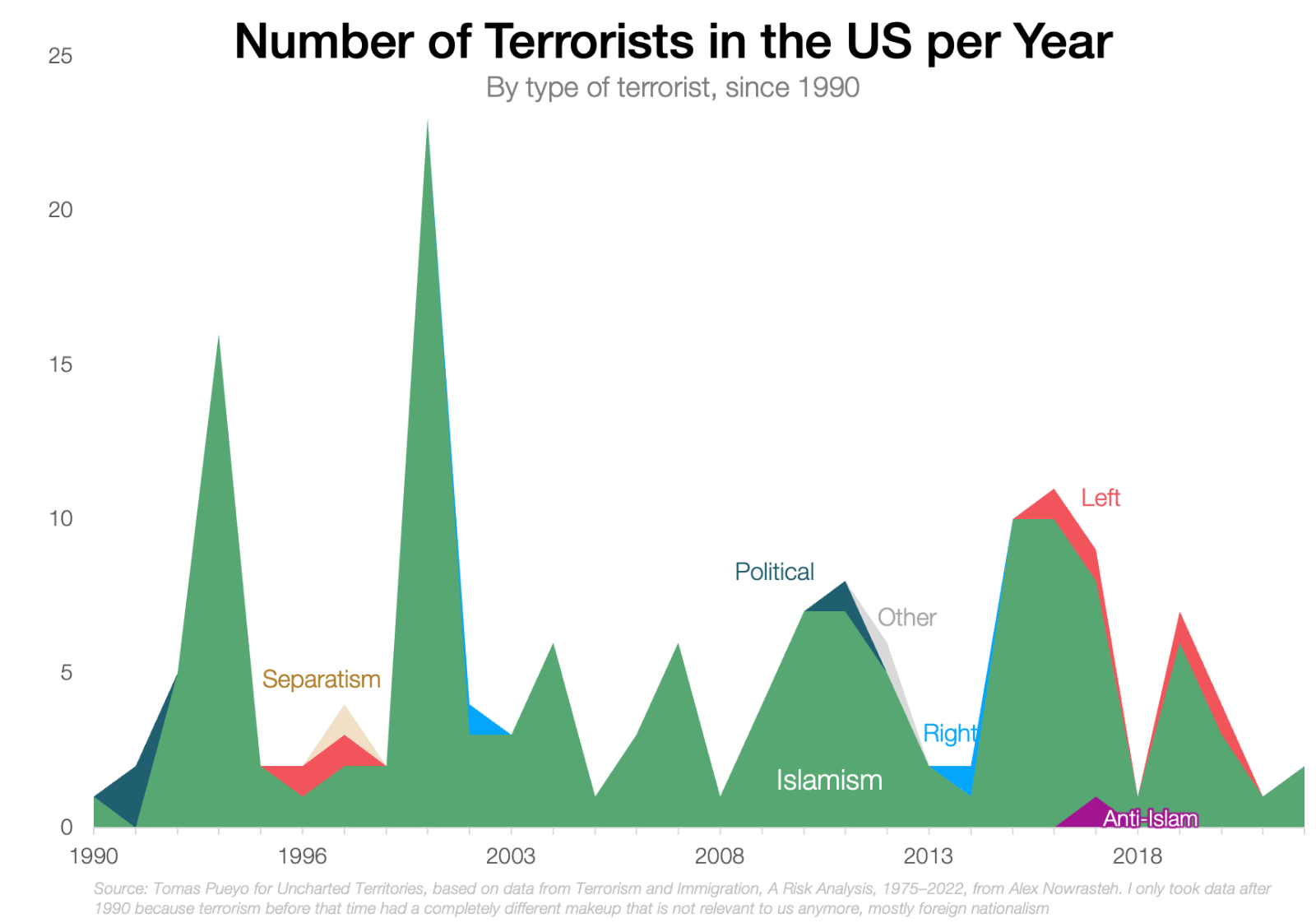
We’re unfortunately used to men killing people while yelling Allahu Akbar, with several dozens of such attacks in the last 10 years. The last Allahu Akbar attack was one just a few weeks ago in Switzerland.
Terrorism is unique in its impact, but also in the ease of proving its causality. It’s very clear when a terrorist attack has been caused by Islamism. It’s less clear in everyday crime. As a reminder, there is an overrepresentation of Muslims in crime statistics in the West, but is that due to Islamism? Or the age of people? The specific culture in some origin country? Islamism is certainly not at fault in all cases. But in some.
Last week, an MP in the UK Parliament read testimonies of some of the British girls who were raped by the Grooming Gangs I mentioned earlier—some of them by several hundred men. The testimonies are graphic, so I won’t repeat them all, but you can watch them here.
Here are the relevant ones for this article:
“Comments were constantly made suggesting that White girls, that Christian girls, were viewed as having fewer morals, or lower values, whereas Muslim girls were described as having dignity and higher moral standards. These comparisons were used to justify the way I was treated, and to further humiliate and control me.”
“Race did play a part and motivated the selection and demographic of the victims. Throughout my exploitation, the other girls I encountered or who were abused alongside me were almost exclusively White.”
“Things would escalate around Eid [the festivity at the end of Ramadan] and holidays, parties got bigger, got worse, got more violent.”
“The main clash that I had with the religion side of it was I grew up as a Christian. I would wear my cross because it was something really special to me. It was just used as a way to break me down. They said: ‘Where is your god now? Has your god forsaken you?”
“It was all of the White girls in every home that I went to. I remember a man that went to the back of a van, and I saw 15, 20 girls locked in dog cages.”
Of course, these crimes were most likely not perpetrated to further Islam, but they’re frequently the result of a mindset in which the Muslim in-group is protected and the out-group attacked, given the most common national heritage of the perpetrators, the fact that sometimes hundreds of them were involved,24 the nature of the victims, and the quotes above. The most likely read is that this is downstream of the Islamism we mentioned before: Many of the perpetrators shared an Islamist belief where the law of the land was less important than the protection and advancement of the community.
This, however, would have been impossible without abetting from the rest of society—again, because of Islamism
In the Rotherham case (~1,400 girls raped):25
Several [council] staff described their nervousness about identifying the ethnic origins of perpetrators for fear of being thought racist; others remembered clear direction from their managers not to do so.
There was a widespread perception that messages conveyed by some senior people in the Council and also the Police, were to 'downplay' the ethnic dimensions of CSE.
This fear of being called racist is relevant, as this is in fact a consistent accusation from Muslim organizations. Many times, these are valid. Islamophobia is real, and has serious consequences. Muslims in the West have been shot, run over, and stabbed because of it. They have faced discrimination in employment, housing, and schooling, and suffer from insults and harassment. It is right to decry it.
Other times, however, the criticism is not of islamophobia, but of islamismophobia. It’s not against Islam, but against Islamism. Yet many Muslim leaders purposefully fudge these two, to protect Islamism under the umbrella of Islam.
"Islamophobia" is the password Islamists whisper to walk past the gates.
For example, something stunning happened in Australia last year. A few Muslim nurses boasted that they had killed Israeli patients, and that they would do it again.
In that situation you’d expect the moderate Muslims to decry them. Over 50 Muslim organizations or leaders came out to defend them!26
Let’s lay out the problem clearly:
There are some normal Islamic behaviors and some Islamist ones.
The Islamic behaviors get improperly criticized (islamophobia). The Islamist behavior gets properly criticized (islamismophobia).
Islamist leaders purposefully fudge the two and call both “islamophobia”.
Since Western leaders don’t know how to differentiate between islamophobia and islamismophobia, and they want to treat people equally (human rights), they start policing each other to eradicate islamophobia. Inadvertently, they also shut down islamismophobia.
This opens a path for Islamism to grow.
The key points above are 3 and 4. Let’s take examples of them. First, how Islamist leaders fudge islamophobia and islamismophobia, like in the case of the Australian nurses.
An Islamist group created the Muslim Council of Britain (MCB), which the UK government has said consistently opposed programmes by successive Governments to prevent terrorism. For example, it opposed naming 21 Islamist organizations (including Al Qaeda) as terrorist.27 The MCB spent 80% of its charity budget on the Center for Media Monitoring, or CfMM, whose entire goal is to monitor British media to accuse them of islamophobia. This could be a great goal if, indeed, it called out only islamophobia. It doesn’t.
The CfMM called a report of “a knife-wielding man yelling Islamic slogans” islamophobic.28 It called the reporting on the grooming gangs “shoddy science underpinning a narrative favoured by the media.” A coordinated takeover to islamize state schools, proven by the government? According to the CfMM, it was a hoax. It recommends eliminating the terms Islamism and Islamic extremism: If they don’t exist, you can’t accuse people of them, and thus any criticism must be islamophobia!
This would not be a problem if the CfMM was an obscure organization without repercussions. Alas, it has engaged with over 1,000 journalists, editors, regulators, and policy makers, including the BBC29, the Sun, the Express, the Daily Mail… It organized feedback sessions for the BBC and fed into its terminology book. It was instrumental in developing the press regulator’s guidance on the reporting of Islam.30 It has trained journalists from The Standard, The Independent, and Scottish TV. It pressured the BBC to withdraw an inconvenient interview clip (the BBC caved). It recommends flooding newspapers with complaints when they report negatively on Islamism:
If they don’t verify what they are reporting, they are going to get flooded with people emailing them and complaining. And that will discourage them from doing it in the first place, because it costs them, in effect, money, because they have to pay their staff for every hour that they are looking at corrections and looking at complaints.
Let’s move on to another organization. Still in the UK, the National Association of Muslim Police (NAMP) represents the most Muslim police officers. This should immediately heighten your senses, because it’s precisely the type of organization where Islam the religion can translate into Islamism the political movement. As such, you should expect them to be extremely thoughtful in separating Islam and Islamism. Yet last year, it published this document, Confronting anti-Muslim hatred and Promoting Human Rights. The entire document tries to claim that Islam is always good, that what bad people do in the name of Islam is therefore not Islam, and so we should completely remove the concept of Islamism. Of course, if Islamism doesn’t exist, any criticism of Islamism must be… Islamophobia. Here are some excerpts.
Terms such as 'Islamist' blur the distinction between extremism and the peaceful practices observed by the majority of Muslims, perpetuating anti-Muslim hatred and casting unwarranted suspicion over the entire religion.
See what they did? They say calling people “islamist” is racist! Absolutely not! It’s the exact opposite! Terms like Islamist allow us to separate between extremism and peaceful practices!
The following passage is also informative:
Islamic teachings advocate for peace, compassion, and fairness, principles diametrically opposed to the motivations behind religiously justified violence. Media, policymakers, and society at large must exert concerted efforts to distinguish between the distorted political or violent interpretations of religion and the genuine practices of its followers.
Later, it tries to erase the word “Islamist”, and replace it with words like “right-wing terrorist”31. In other words, it’s trying to hide the fact that the extremist religious beliefs behind political Islamism cause Islamic terrorism! And then blame these instances on the right! This represents the police speaking!32
You can see the pattern here. First, Islamism is too broad, it doesn’t represent Islam, let’s not use the term. Then, call criticism to Islamism islamophobia. Accuse the authors, and train the media in avoiding any criticism altogether.
What is the result of all this effort? What is the attitude of Western leaders about criticising Islamism? Reporters have said that accurate stories were not published for fear of being branded islamophobic, that the CfMM and other activists would be able to use any official definition of “Islamophobia” to suppress their reporting, that a newspaper discouraged a journalist from writing about Muslims because the CfMM complained he wrote too many stories about Muslims…
This fear of being called racist, xenophobic, or islamophobic33 has enabled what The Telegraph reported on the Telford Grooming Gangs:
Aware that taxi drivers were offering children rides for sex, in 2006 [the council] suspended licensing enforcement for drivers, allowing high risk drivers to continue practicing, “borne entirely out of fear of accusations of racism; it was craven”.
Senior council staff were terrified that the abuse of children “had the potential to start a ‘race riot’”. The result was stasis, despite officials acknowledging in at least one case that abuse by Asian men had gone on for “years and years”.
A senior police officer allegedly said the abuse had been “going on” for 30 years, adding “with it being Asians, we can’t afford for this to be coming out. Politicians were terrified [of the impact on] community cohesion.
As a result of this combination of factors, the council went to great lengths to “cover up information and silence whistle-blowers”. In the words of witnesses, “if you want to keep your job, you keep your head down and your mouth shut”.
The police, the council, and the entire community failed to stop behaviors downstream of Islamism because of their fears to be called islamophobic. Here are other examples of anti-Islamist actions stifled by the fear of being labeled islamophobic:
In the Islamist Manchester Arena bombing that killed 22 people and injured over 1,000, a security guard didn’t stop the perpetrator before the attack for fear of being branded racist.
After a French teacher was beheaded by a Jihadist over the false accusation of a student34, the response from the state and the media was not supportive enough, and now 40% of French teachers say they self-censor on sensitive topics.
According to the UK government, “fears of being accused of being racist, anti-Muslim, or culturally insensitive may inhibit Islamist-related referrals”.
Channel 4 had a documentary about grooming gangs ready to air in 2004, but didn’t “over fears that it could lead to race riots”. Grooming gangs would continue for over a decade.
The South Wales police has been told to log every event where a person is accused of islamophobia, therefore leaving a public record against critics of Islam and Islamism. No other religion has anything like that.
On New Year’s Eve of 2015, over 1,000 women were sexually assaulted in Germany (especially in Cologne) by large groups of North African and Arab appearance. The police originally labeled the night as “Cheerful mood—celebrations largely peaceful”. A later report included the word rape, which a minister’s office allegedly35 asked to remove. Newspapers had to apologize for covering them up
An Islamist who killed 14 people in California in 2015 was not reported by neighbors for suspicious activity because she didn’t want to profile him.
Denmark has made it illegal to burn the Quran, to placate Islamists.36
So that’s the mechanism by which Islamists stifle freedom of speech, which then prevents the West from calling out its problems. And that bleeds into day to day coercion.
This Sikh had to close his restaurant because of Pakistani harassment when he said he didn’t serve halal food:
This debate ended when a Muslim student stood up to threaten a Jewish student and then repeatedly yells “Allahu Akbar”.
This is a Church being desecrated in the UK:
I’m reminded of the behavior of pro-Palestinians in New York a few years back:
Apparently37, this video depicts girls in Antwerp, Belgium, being verbally attacked and groped on a bus for not wearing veils, and for showing too much skin.
These women were harassed on the street because of what they wore:
The poster, an Iranian journalist, added:
“When I say that Germany has its own “morality police,” I am referring to the so-called “Sharia Police,” self-appointed enforcers of Sharia law. I have received direct messages from many Iranian women sharing their concerns about morality enforcers in European countries, who are often silenced and labeled Islamophobic, anti-immigrant, or right-wing.
Whether we like it or not, these Sharia or morality police known as “Amr bi al-maruf”, a collective duty of Muslims to encourage righteous behavior and discourage immorality, exist in many European countries. Often linked to mosques, they impose their version of religious law, targeting women and girls for not wearing the “proper hijab.” This mirrors the experiences of women in Iran. In Iran, when Sharia Police violently harass women for not covering their hair, officials often mislead the world by claiming these are just religious groups, not the official police.
Sources in the Muslim community in Germany report that these so-called Sharia Police have appeared in cities like Wuppertal and Berlin, harassing women under the guise of promoting hijab and Sharia laws. This issue extends beyond isolated incidents, with moral enforcers emerging in schools and neighborhoods with Muslim majorities.”
Here’s another woman harassed by this local Islamist policing.
This Spanish girl had to leave the beach because of sexual harassment by North Africans. She didn’t want to be racist and sat nearby. She didn’t report it for the same reason.
Going to a beach and pointing fireworks at beachgoers while screaming “Allahu Akbar” should not be allowed.
This man is saying that blasphemy deserves death.
This guy harasses girls and old men, but is not in prison because people don’t report him, and they don’t report him because police, the media, or society might call them islamophobic.
Another example here.
Just to be clear, all these behaviors are not just anti-social. They’re illegal: coercion and harassment. Their erosion of public life might not be ideological (these people are not trying to impose Islam) but they’re fueled by Islamism in two distinct ways.
The first is impunity. These acts exist because reporting them, policing them, or naming the pattern carries a social cost, the cost of being called racist or islamophobic, which is precisely the cost the organizations described earlier work to manufacture.
The second is the imposition of an Islamist world view: a woman's visibility is a legitimate object of male policing, blasphemy is an injury that warrants force, burning a church’s door is acceptable because Christians don’t fight back, screaming Allahu Akbar scares people… all of these are downstream of a political project that taught the Islamist script. An ideology works most powerfully once it stops looking like an ideology and becomes simply how things are.
This is how the universal human rights for which Western societies have shed so much blood die a slow death.
So what can we do about it?
As we said, Islamophobia is real and many Muslims suffer from it as a result. It’s bad because it attacks a religion and the people who follow it.
But it’s also bad for the islamophobes themselves. The more islamophobia there is, the more Muslims feel bundled as a whole, rejected by their religion. They get radicalized, or don’t stop the extremists anymore (they’re in the same bundle, at the end of the day). That galvanizes Islamism, which then promotes actions that fuel further islamophobia, in a terrible vicious cycle.
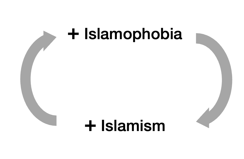
But also, the examples in the previous chapter are not an expression of Islam. They’re an expression of Islamism, and Islamism is a threat to human rights that can’t be tolerated.
To break the cycle, we must differentiate between islamophobia and islamismophobia.
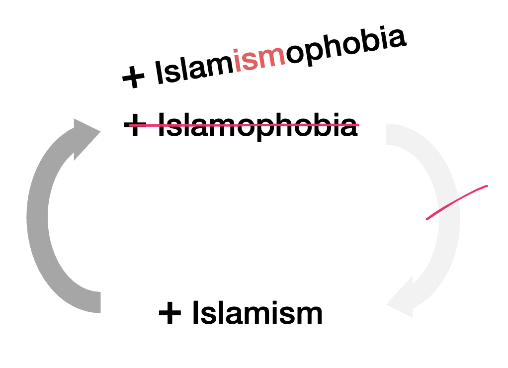
Moderate Muslims are islamismophobic too. They are as appalled as you or me by these behaviors. They want them to end. And they can only end when we call them out for what they are: Not isolated incidents, but the expression of Islamism, the political side of Islam that tries to coerce others into the religion or face consequences, which means it’s against universal human rights.
So here’s my message to each group.38
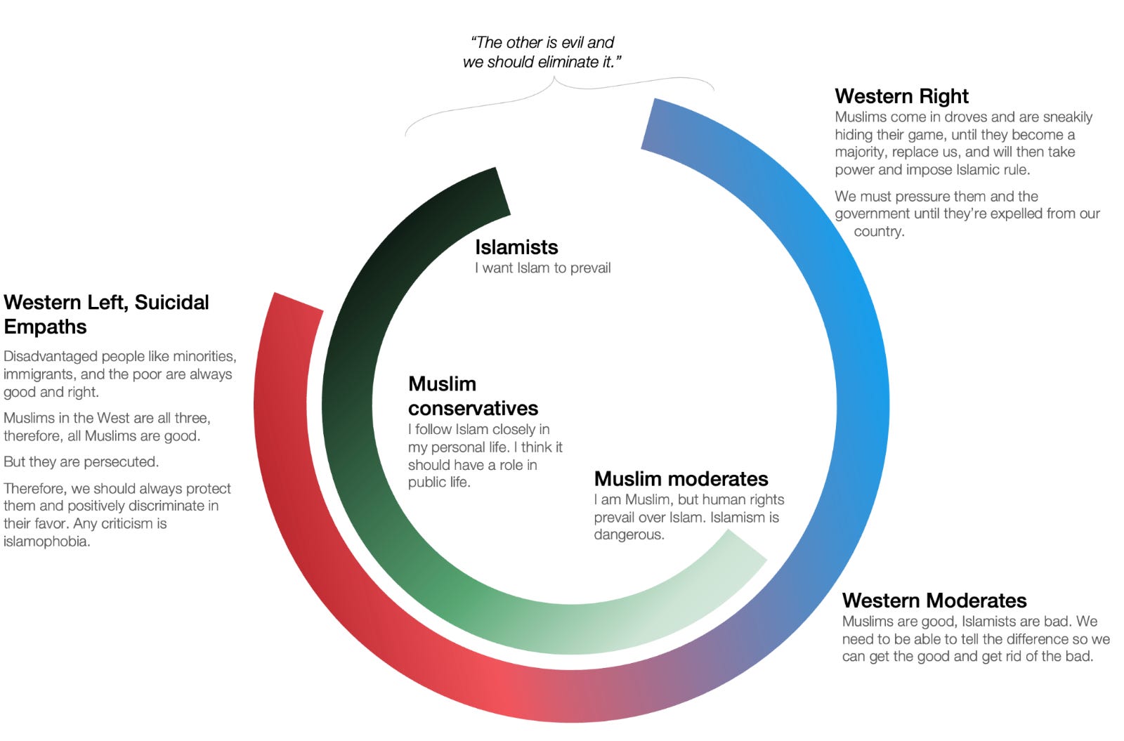
You’re in a difficult position. You have your personal, legitimate faith, which on one side, Western society pressures you to abandon, and on the other, Islamists push you to radicalize. When these two sides clash, you’re caught in the middle.
You can help solve this problem by drawing a clear line between yourselves and Islamists. That way, you can blame the problems on the true cause (Islamists), and not on Islam.
Always keep that narrative in mind. If there’s a terrorist attack? You can say: “These are Islamists. Islamism is a political ideology that tries to impose Islam on others. It’s a scourge and we need to get rid of it. This does not represent me, nor a majority of Muslims. I defend human rights.”
If you do that, it will be clear that you are on the side of human rights, and you are enemies of Islamism. It will be much easier to fight it.
The harder fight might be on a day to day basis. When somebody decries islamophobia that is islamismophobia, we should all correct them, but your voice carries more weight than anybody else’s. When somebody coerces, harasses, or erodes civil life, we should all call them out, but if the perpetrator seems to be Muslim, it’s even more important and valuable that you do.
Some conservative Muslims might prefer to fudge the line between Islam and Islamism, but it’s important that you help them clarify it. There really are only two sides to this: Either you’re in favor of human rights, or in favor of Islamism. There isn’t an in between. Islam is compatible with human rights; Islamism is not. As conservative Muslims’ strongest connection to the rest of Western society, it’s important that you help them see that.
Stop conflating Islam and Islamism.
It’s OK to want to eat halal.
It’s OK to want to wear a hijab.
It’s OK to abide by Sharia Law for yourself, as long as you also respect civil law.
It’s OK to build a mosque.
It’s OK to sound a call to prayer in public.
It’s OK to pray in public, when your creed tells you to.
It’s OK to disapprove apostasy and blasphemy.
It’s OK to be a Muslim immigrant.
It’s OK to open a new mayoral term with a Muslim prayer.
It’s OK for Western schoolchildren to go to the mosque to learn about Islam.39
It’s OK to celebrate a specific Islamic event in public.40
All of these are Islamic, and they’re OK. You should not denounce them. That’s Islamophobic. You should be able to differentiate them from Islamism, for four reasons.
First, if you don’t, you’re against the universal human value of freedom of religion, a core bastion of the Western values that you claim to respect.
Second, when you attack a legitimate religion, you attack all of its members. More specifically, you alienate the 20–50% of moderate Muslims who are also fighting the Islamists, because you’re putting both in the same bucket, so they’ll want to defend themselves together. The more Islamophobic you are, the more you’ll radicalize Muslims.
Third, you also alienate the left, who will have a legitimate beef with you.
Fourth, by eliminating your islamophobic thoughts and remarks, you can leave only islamismophobic ones. Every time somebody accuses you of islamophobia, you will know they’re wrong, and you’ll have a good opportunity to educate them on the very important difference between Islam and Islamism.
It’s important to call out islamophobia, and any other type of discrimination.
It’s equally important to make the distinction with islamismophobia, because Islamism is quite common. Otherwise, you’ll be unwittingly abetting Islamism, losing your moral clarity, and undermining the human rights that are so important to you.
Islamism is against some of the most important rights you’ve fought for: those of women and LGBTQ+ people. But they’re also against other very important rights: freedom of religion, freedom of speech, animal rights (dogs). Virtually everything Liberals fight for is against what Islamism wants.
Finally, the Left allied with the Islamists in Iran in the 1979 revolution. As the Islamists took power, they turned against the Left. The alliance between Left and Islamism is a one-way relationship.
So first, realize that one of your biggest enemies is Islamism.
When you see a behavior that triggers your concerns about islamophobia, stop for a moment and think about whether you’re actually seeing islamismophobia. If it’s against Islam, you should decry it as islamophobia. If it’s against Islamism, you should join the criticism.
This also means you have to stop the knee-jerk reaction of labeling everything as far-right islamophobia or racism. For example, the head of a French extreme-left party called a law against the Muslim Brotherhood islamophobic. It’s not, it’s islamismophobic. He's enabling Islamism. Banning another Islamist organization has also been called islamophobic.41
Politicians who want to do the right thing are also in a tough spot:
Right-wing politicians conflate Islam with Islamism to stoke hatred and call for the expulsion of all Muslims and immigrants
Left-wing politicians call any reaction to Islamism “islamophobia” and use racism to incite conflict with the right
Emotions garner votes, so moderate parties bleed voters on both sides
It’s not always easy to tell what should be acceptable and what shouldn’t.
But I believe the vast majority of people are reasonable. They want Islam and don’t want Islamism. So here’s what politicians should consider:
Is an action consistent with a personal belief? Then it’s OK.
Is it consistent with Islamism (or any other politically extremist view that tries to undermine universal human rights)? Then it should be fought.
This has ramifications for many policies to fight both islamophobia and Islamism, such as policing, free speech, and immigration. We’ll cover these and more in the next article.
Islam is personal and persuasive. Islamism is communal and coercive.
If you’re in favor of human rights, you’re in favor of freedom of religion, and you’re in favor of Islam.
If you’re in favor of Islamism, you are supporting a political movement that is trying to eliminate other religious beliefs and individual freedoms. You’re against human rights.
So it’s crucial that we differentiate between Islam and Islamism. If you want to do that, you can ask questions like:
Should civil law always be above Sharia law?
Are women equal to men?
Is homosexuality acceptable?
Should people be allowed to have dogs?
Should it be legal to eat pork?
Should it be legal to leave the Muslim faith?
Should it be legal to burn the Quran and draw the Prophet Muhammad?
A moderate Muslim would answer yes to each.
A conservative Muslim might say: “I disagree with these personally, but I respect the rights of others to do and think these things.”
An Islamist would say no to some or all of them.
This will highlight the bright line between Islam and Islamism, drawn by universal human rights.
Judaism and Islam emerged from pastoral societies, where the state was weak. As such, they both proposed rules that cover spirituality and state law. They give plenty of details on what you should and shouldn’t do, and what the consequences are for each action. Meanwhile, Christianity emerged under a very strong state, the Roman Empire, and so it purposefully focused on morality and spirituality, avoiding the state’s role in shaping law. This is why Jesus said “My kingdom is not of this world.” These roles quickly blurred (Christianity became part of the Roman Empire, Islam created states), but the original influence explains this divergence we see nowadays. The result for Islam is much more prescriptive on people’s day to day life, from what to eat, how to dress, who to marry, how to divorce, how to deal with foreigners, etc. This law is not always clear in the Quran, so the Hadiths tried to interpret it a few centuries later, based on what was written in the Quran, and what was known at the time from the living memory passed down over generations, including reports about Muhammad’s sayings, actions, approvals, and conduct. Since the Quran is frequently ambiguous, the Hadiths were much later than the Quran, and the process to gather them was highly political, there are different Hadiths, who differ in substantial aspects. We can see the interpretability of these texts through the Shia / Sunni gap, which emerged immediately after the death of Muhammad, and was cemented over the following centuries, including through Hadiths: Each school follows different ones. From then, there has been a scholarly evolution of interpretations of Quran and Hadiths, which have led to very different interpretations of what Sharia law should be. This means that there’s not one single Islam, that legitimate Islamic beliefs can differ widely from each other.
The Islamism table above is doing two things at the same time: It’s bundling within Islamism coercive behaviors and, sometimes, speech. This is purposeful, because Islamism is not a behavior, it’s a system of thought. That thought is against universal rights and can sometimes translate into behavior. But shouldn’t free speech be protected, including Islamic speech? Otherwise, isn’t that specifically targeting a religion? This is what this article is about.
“Constistent” doesn’t mean that all Islam says this. It just means that Islam can be consistent with the views on the left of this series of questions, while Islamism will tend to be consistent with views on the right. Traditional interpretations of Islam (like those of other religions) are in some areas tolerant, in others less so, depending on who you ask.
Notice this is slightly different from what I said before on the Islam column. There, I mixed moderate and conservative Muslim views, but excluded Islamist views. Here, I’m highlighting moderate positions.
Note crucially that Turkey and Qatar have not.
From here, transcribed with Turboscribe, translated with ChatGPT
The national data in the UK is not good enough to tell. There are four Grooming Gangs that are known, though. In those, the perpetrators were usually Pakistani. In some cases, also North African or East African. The victims nearly all White. The reports consistently showed that authorities suppressed action in fear of being called racist. When you look at lists of convicts, the individual names of perpetrators include Asad, Ajmal, Mohammed, Ahmed, Taukeer, Mohsin, Javid, Haroon, Zahir, Wajid…
Case in point, Pakistan just condemned two men to death for raping a French tourist woman in front of her children.
And dozens and dozens of moderate Muslim organizations. From ChatGPT: UK: British Muslims for Secular Democracy; Muslim Women’s Network UK; Inclusive Mosque Initiative; Nisa-Nashim; The City Circle; Muslim Youth Helpline; Ahmadiyya Muslim Community UK.Germany: Liberal-Islamischer Bund; Ibn Rushd-Goethe Mosque; JUMA — jung, muslimisch, aktiv; HEROES Germany; CLAIM; Muslim Jewish Leadership Council.France: Musulmans Progressistes de France; Lallab; Homosexuel-le-s Musulman-e-s de France; Coexister; Les Bâtisseuses de Paix.Netherlands: Stichting Maruf; Femmes for Freedom; Al Nisa; Yoesuf Foundation; European Queer Muslim Network.Belgium: Merhaba; Kif Kif; BePax; European Muslim Network; European Queer Muslim Network.Denmark: Democratic Muslims; Exitcirklen; Sabaah; KVINFO-affiliated Muslim women’s initiatives.United States: Muslims for Progressive Values; Muslim Reform Movement; American Islamic Forum for Democracy; Muslim Public Affairs Council; Muslim Alliance for Sexual and Gender Diversity.Canada: Canadian Council of Muslim Women; Muslims for Progressive Values Canada; Noor Cultural Centre; Canadian Muslim Vote; Ahmadiyya Muslim Jama’at Canada.Australia: Muslim Women Australia; Australian Muslim Women’s Centre for Human Rights; Islamic Council of Victoria women’s initiatives; Together for Humanity.
This is a simplification. Depending on the country and questions, this estimate is going to be 10-20% for radical Islamist positions, with a large group of 20–50% additional people who hold conservative views that might bleed into Islamist attitudes.
With the caveat that, sometimes, the word “justice” is used as a stand-in for Sharia, especially when
All Arabic is transcribed by TurboScribe, translated by ChatGPT (shared when ChatGPT allows), edited by me for length to focus on what I consider the Islamist positions.
Transcribed by Turboscribe. Translated by ChatGPT.
This is not an imam but the leader of the MB in the UK
All the data below is extracted from these reports, through NotebookLM. It might contain some mistakes, but I spot-checked and didn’t see any.
In the UK they established the Islamic Society of Britain (ISB), dominated the Muslim Association of Britain (MAB), and played a critical role in establishing the Muslim Council of Britain (MCB), which successfully sought dialogue with the UK government. In France, the movement built a solid network over 40 years around a central umbrella structure, Musulmans de France (formerly the UOIF), which currently manages 139 affiliated places of worship (about 7% of all mosques in France). Across Europe, they established the Federation of Islamic Organisations in Europe (FIOE)—now the Council of European Muslims—to act as a massive umbrella for MB-linked groups across the continent. They also created the Forum of European Muslim Youth and Student Organisations (FEMYSO) to mobilize youth and conduct political lobbying.
European Council for Fatwa and Research (ECFR)
There’s no data on this, and the MB is a broad umbrella anyway, but if you add up all the money uncovered by different reports from different countries, it can easily reach that number, and probably higher.
The Qatar Charity NGO has poured millions into Europe to finance MB mosques and projects through its "Ghaith" program. In Spain alone, Qatar Charity funneled approximately 17 million euros by 2015 to construct and expand MB-linked hubs, including the Islamic Cultural Center of Catalonia in Barcelona.
The Islamic Cultural Center of Valencia (CCIV) became so active in local integration and youth issues that they successfully secured hundreds of thousands of euros in public subsidies from regional governments and city councils. They even established partnerships for sociocultural projects with private entities like the Obra Social Caja Madrid.
It is not the only one. For example, countries with a lot of immigration that settle in enclaves will be living among peer immigrants, and the pressure to integrate will actually be weaker than that of the previous generation, which was a smaller minority so suffered more pressure to integrate.
Governor of Punjab until 2022.
Jama'at Nusrat al-Islam wal-Muslimin
How can you find hundreds of people willing to participate in such a crime if they are not all willing to protect each other?
This mixes religion, immigration status, race, and government action, so it’s out of full scope for this. I will cover it more in another article.
Here’s the original letter, here’s a transcript. Here’s exactly what it says about the behavior of the nurses: “Healthcare should be provided justly to all. [...] We recognise the importance of professionalism and ethical responsibility within healthcare and that the nurses' actions breached the codes of conduct for health professionals. The statements made by the nurses regarding "killing Israelis" were clearly emotional and hyperbolic, as supported by subsequent investigations. Healthcare professionals are bound by their duty to treat and care for all individuals.” If you pay attention, there is zero condemnation. The rest of the message is about how this is manufactured outrage to cover uphide the deaths in Gaza.
Just to give you more examples. Here you can see it claimed 45% of all hate crime offenses targeted Muslims. But in fact it’s only 45% of religious hate crimes. It was 2.2% of all hate crimes. It probably purposefully mixed denominators (religious hate crimes instead of all hate crimes) to make the stat look shocking. It has continued making similar claims
The section is introduced as: “Certain articles are embellished with extraneous details to the story and don’t provide any further context to the incident being reported on. The purpose of their inclusion seems to be targeted at portraying Muslims and/or Islam in a negative manner.” Among others. Many more examples in the link. Table 13, page 104.
The CfMM met with the director general (who was “very impressed”) and the managing editor of the BBC (who called the CfMM a “powerful machine”).
The only religion for which this was done
It also proposes Irhabist, which is Arabic for terrorist, and Anti-Western Terrorist
There are a few more examples in this document:
These certainly overlap a lot, as over 30 countries are over 90% Muslim. As a result, grooming gangs that were completely Pakistani were also completely Muslim. Sometimes, it’s hard to tell the difference, and they blur. This can lead to either racism, xenophobia, islamophobia, or a combination of them. Here, I am focusing on the impact of Islamism, trying to disentangle it as much as possible. But it’s impossible to do perfectly given the correlations.
She claimed he had expelled Muslim students from a freedom of speech class in which he was going to show a picture of Muhammad. This didn’t happen, and the girl wasn’t even in class that day.
Officers said the state interior ministry's control centre wanted the word 'rape' deleted from an internal report. The minister denied he had mandated that.
Another: In the UK, there are more right-wing terrorism reports than Islamic terrorism ones, despite the Islamic terrorists being much more active and dangerous.
I can’t get the transcription to work, so I’ll rely on the text in the tweet, which might in fact be a mislabel. There were no community notes though.
These aren’t perfectly described groups, but I think they’re good enough.
Same as Muslim children should go to churches to learn about Christianity, but since they already live in a majority-Christian society, they get more exposure than the other way around.
Here’s an interesting example of an NYPD officer who wears a hijab. I think it’s OK to wear a hijab at work. But also, police is a public job, so it should be treated as religiously neutral. Overall, I think it should be possible to wear one as a police officer, but I also respect that other countries might have a different position on this. If they don’t want to allow a hijab though, then no other religious symbols should be allowed, like in France of Quebec. The principle must be the same for all.
Another example: US Congresswoman Rashida Tlaib used the term “From the River to the Sea”. This is a slogan traditionally used to say that the entire region of Palestine (present-day Israel, Gaza, and West Bank) will become Muslim. This is considered Islamist, as it promotes the political expansion of Muslim rule over what is today not Muslim rule. She was censored for it. The censoring was called Islamophobic. I think this example is a bit muddier, because it’s arguable whether the entire logic here is valid. Maybe actually Tlaib didn’t mean that, and maybe that’s a contentious edge case of Islamism. But for the same reason that it’s unclear whether her statement is Islamist, it’s unclear whether her censuring is islamophobic.The movement Queers for Palestine legitimately worries about the plight of Gazans, but it should note that ~95% of Gazans don’t accept gay relationships, that the ruling Hamas is supported by a large share of Gazans, and that Hamas is a terrorist Islamist organization.
2026-06-03 03:52:34
This is the 6th and penultimate article in the series of immigration in the Western world. We’ve seen that:
However, today, immigrants to Europe commit more crime and terrorism, can undermine social cohesion, work less, and consume more welfare than natives.
Muslim immigrants tend to be overrepresented in these stats. To understand better why, we looked at the beliefs of Muslims in their native countries and in the West.
We also pondered how we should think about immigration: Who to welcome or reject, and how to best manage them.
So today, we’re going to apply all this to suggest the best policies Europe can adopt to improve its immigration.
If you take immigration as a system, you need to:
Get the best people in
Reject the worst ones
Make the most of the ones you got in
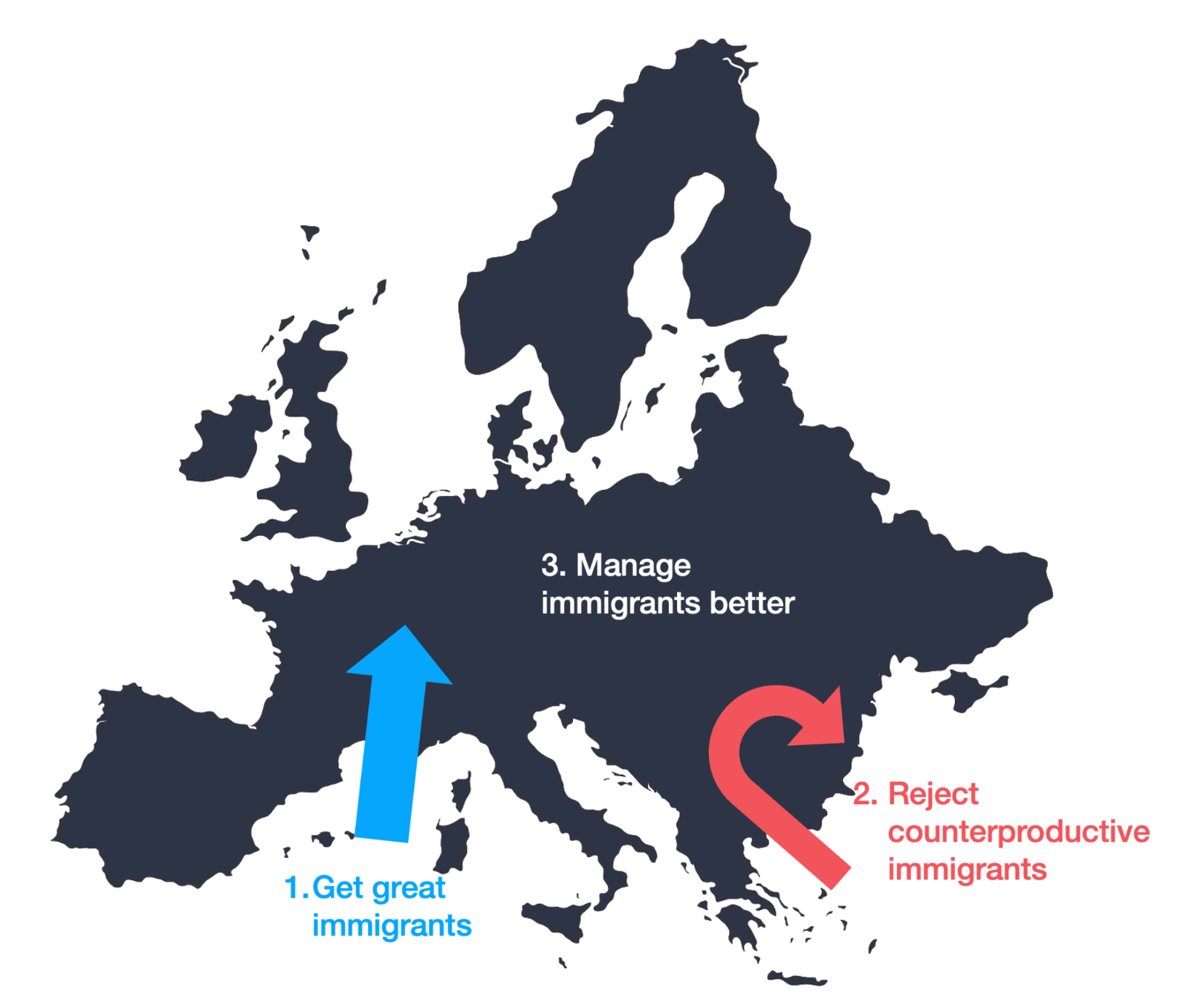
Virtually every study I’ve read shows the same thing: Immigrants who come to work tend to be beneficial, and the high-skilled ones are the best, so that’s what Europe should aim for.
France now says it has reached its limit of immigrants, but how many is that? And why?
This is the most basic thing. Countries should know quite precisely how many immigrants they need. That number should be published, and success should be tracked against it.
Immigrant countries like Canada, Australia, and New Zealand do it, but most others don’t. They have caps for certain visas, or expected arrivals, but no goals to aim for.
Counterintuitively, if there’s one group that doesn’t need targets, it’s high-skilled workers.
They are nearly always positive net contributors. They commit less crime, work more, make more money, spend more, pay more taxes, increase innovation, and create more jobs. And this is all independent from background nationality or religion.
The EU has already improved the bureaucracy to get this type of immigrant with the Blue Card, but only a tiny share of immigrants come through this process today.
One way to do that is to open many postgraduate degrees in European schools. Let foreigners pay for their advanced education and, once here, allow them to stay and contribute. Joining through a university is also beneficial, because they get a community, friends, and an institution vested in their success after school, all of which increase integration and income.
This can open a loophole though, where universities have an incentive to accept foreign students with dubious credentials, as a way to bypass immigration barriers, so the government should vet these credentials. Foreign students who don’t have valid ones should follow a process of validation / remedial work / cultural acclimation / denial.
Another thing they can do is piggyback on other countries’ vetting systems. Canada did this for a short period, accepting high-skilled US immigrant workers. We should see more of it.
Another thing Canada does well is its point system, which allows it to evaluate the potential contribution of immigrants. It apparently succeeds at selecting immigrants well (even though the country doesn’t always succeed at making them productive).
Personally, I’d also target India and China specifically: Together, their populations account for 35% of the world’s population. If you can get the best and brightest from there, even if they’re just 1% of the population, you’d get a flood of high-skilled workers.
But it’s not just high-skilled workers. All immigrants with work visas tend to make more money than any other type.
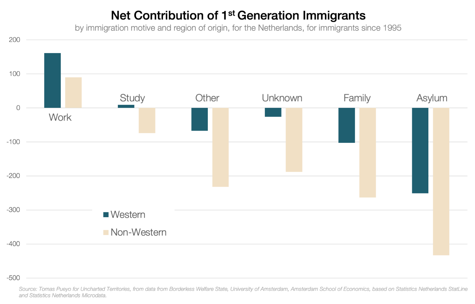
So of course, European countries should prioritize work visas. That’s what happens in countries like Saudi Arabia or the UAE: Immigrants go there to work. No asylum, no family reunification. When I was there, I spoke with many Pakistanis who were happily working there while their wives and children were in Pakistan.
To avoid unemployment, workers need a local sponsor. If they lose employment, they need to find another one. So this is also another way to reunify a family: Get a job sponsor for the wife.
It’s not just Muslim countries. Switzerland does the same:
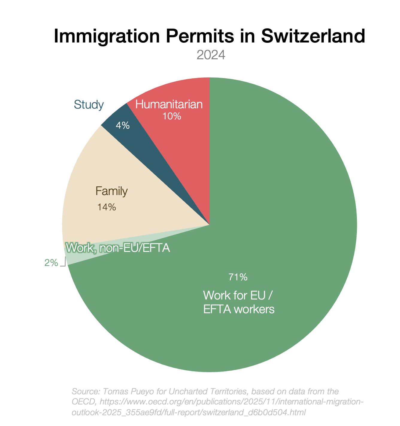
In Switzerland, even EU members need either a job or to prove that they can sustain themselves in order to live in Switzerland. Non-EFTA workers need to prove they would be economically beneficial to Switzerland to be accepted. They are generally all high-skilled; there are virtually no low-skilled non-EU worker visas.
When I was an immigrant in the US, I was sponsored by a company. When I lost my job, I had a limited number of months to find another job before leaving. That makes sense to me.
You’d think “making sure most immigrants come to work” is obvious but look at Belgium.
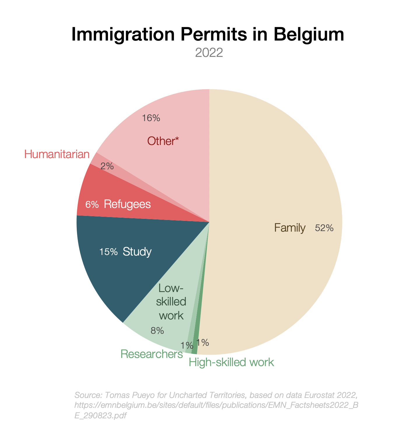
In 2022, less than 10% of Belgian visas were for work!
Of those, only 2 percentage points were for high-skilled work or research! Madness!
So where do the rest go? 15% are for study, which is OK. But a whopping 52% are for family! This is nonsensical. For every work residence permit, there are five family permits! That should be dramatically curtailed.
Does this mean family reunification should be impossible? Absolutely not! The worker should just be able to prove that his income can support the family’s housing, education, health coverage, and the like without requiring welfare. If a worker can’t support his wife, the wife should only come if she can work. We’ll talk more about this later.
The red section in the circle above shows that about 24% of all permits are humanitarian—the most costly, least value-add types of immigrants.1 I think it’s honorable to have a few refugees, but a quarter of all immigrants is completely untenable. According to a Dutch study, they each cost ~€500k in their lifetime!
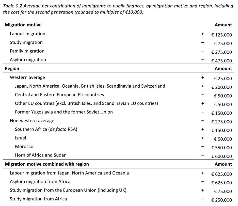
It’s reasonable to welcome some refugees, but the amount should be capped (remember those annual immigration goals?) 25% of a high amount of immigrants sounds unsustainable to me.
Belgium is an outlier, but it’s not the only one. Here is the data for the EU:

The degree of suffering should be better considered. For example, I’d expect asylum seekers from Afghanistan to the UK be mostly women and girls, yet:
You could argue that Europe accepts asylum seekers because it’s the responsibility of rich people to support poorer people, and that makes sense to me. But I respect that this is my opinion and not everybody should share it. Why should that be a public endeavor for a private choice? How are Afghan male refugees the responsibility of the state of Belgium?
The concept of the sponsor visa could be extended here: Those who want to increase the number of asylum seekers should be able to pay NGOs or companies to sponsor them (or do it themselves). They would be in charge of their costs, work, and integration. If these organizations fail frequently at these goals, they should lose pay for the costs of their failures and lose their licenses.2
Pushing this to the private sector would have several additional benefits. One is that private organizations tend to be better at achieving clear cost-benefit goals than public systems. Another is that they’re better at finding original solutions for problems. For example, it can be much better for the origin country and for the destination country to take a small part of that money and use it for development in the origin country. This can create many more jobs, enrich the origin country, and reduce welfare costs, social cohesion costs, and crime in the host country.
In a perfect world, the immigration service would assess every immigrant individually, as Canada does with its point system. But some countries don’t have these systems yet. So what can they do? In the interim, the next best way to select immigrants is based on what a destination country knows about them, like age.
A person near retirement age will consume much more in welfare than they will produce in taxes, so these people should not get permits as easily as their younger counterparts. If they do, they should not retire following the same retirement rules as natives, but much later (in the spirit of the welfare section we will discuss later).
This is the other side of the same coin: Defining which ones you accept means defining which ones you deny. More in detail:
Selecting by age is one of the ways immigrants get an incentive to lie on applications. Look at the bump at ages below 18 in the graph we just saw:
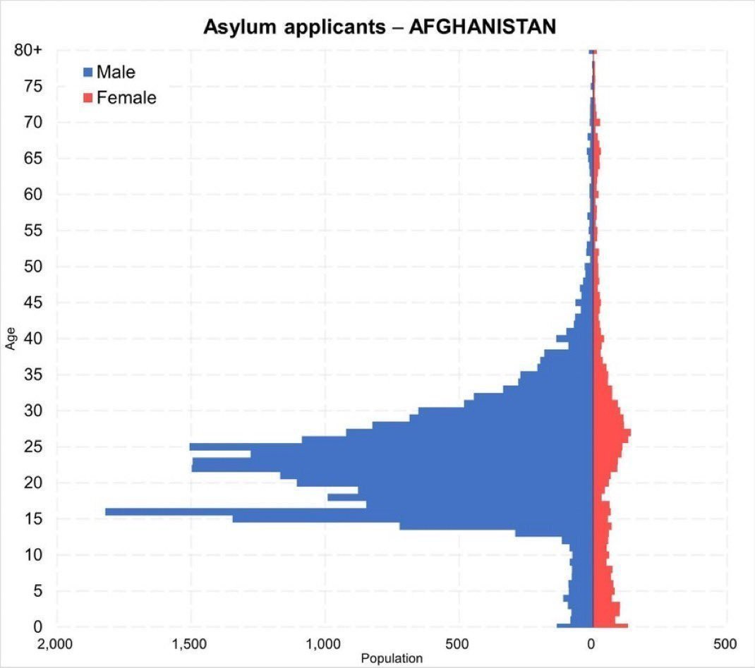
It’s very unlikely that there are two peaks (“modes”). It’s much more likely that these are 18-25 year olds passing as younger to get special benefits.
Other ways in which immigrants have gamed the system have been by claiming statelessness, destroying their papers, forging others…
Gaming the system through lies on applications should be immediate grounds for visa or residence permit denial.
Besides age, the other obvious way to prioritize is by country. As we’ve seen, the most expensive, least productive, and more crime-prone regions tend to be MENAPT, so a reasonable destination country policy would be to install a points system, and until then, deprioritize immigrants from this type of country.
Notice I didn’t say Muslim countries though. Somalians, Afghanis, Palestinians, and Algerians tend to be at the top of the lists for crime and welfare spending, so European countries should be cautious of their allocations to such origin countries.
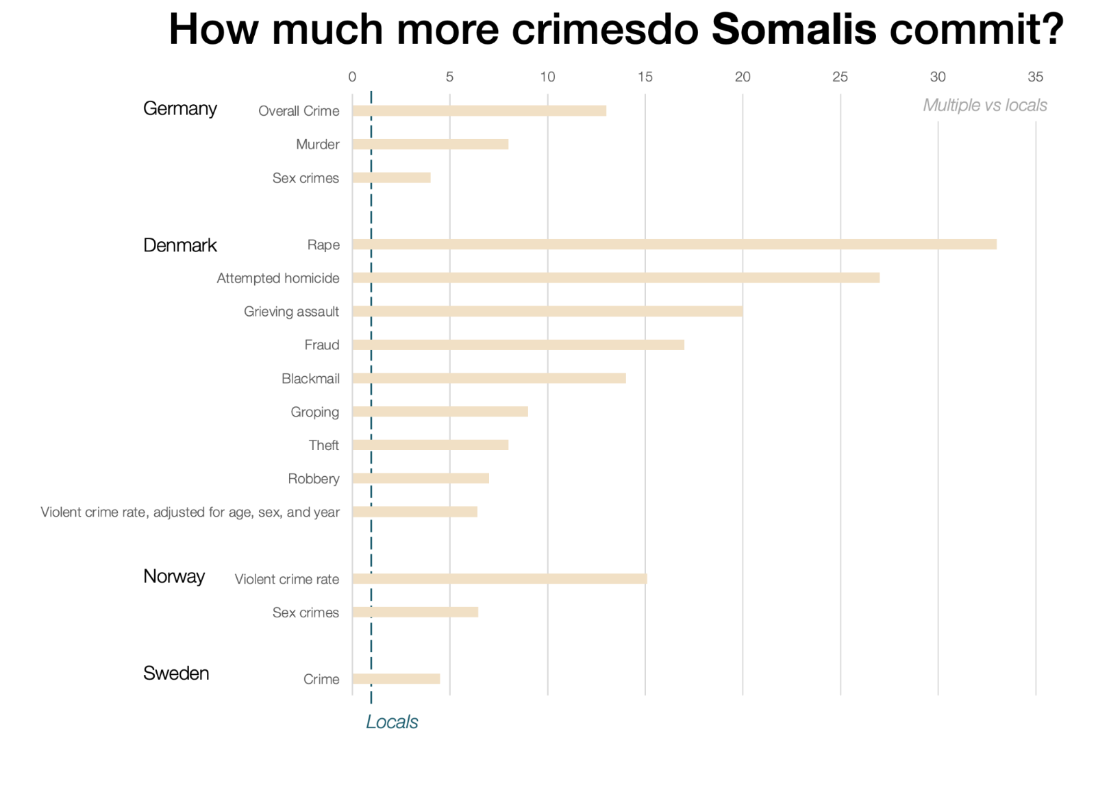
This is for Afghanistan:
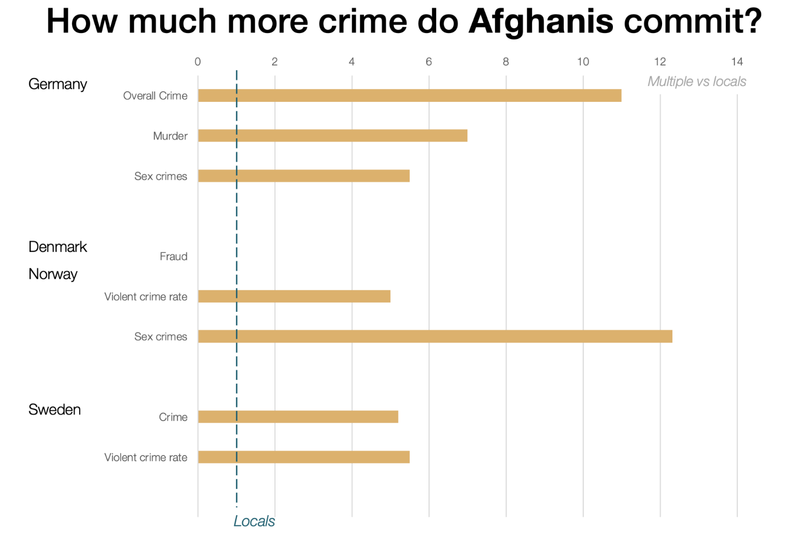
Here’s data for the economics:
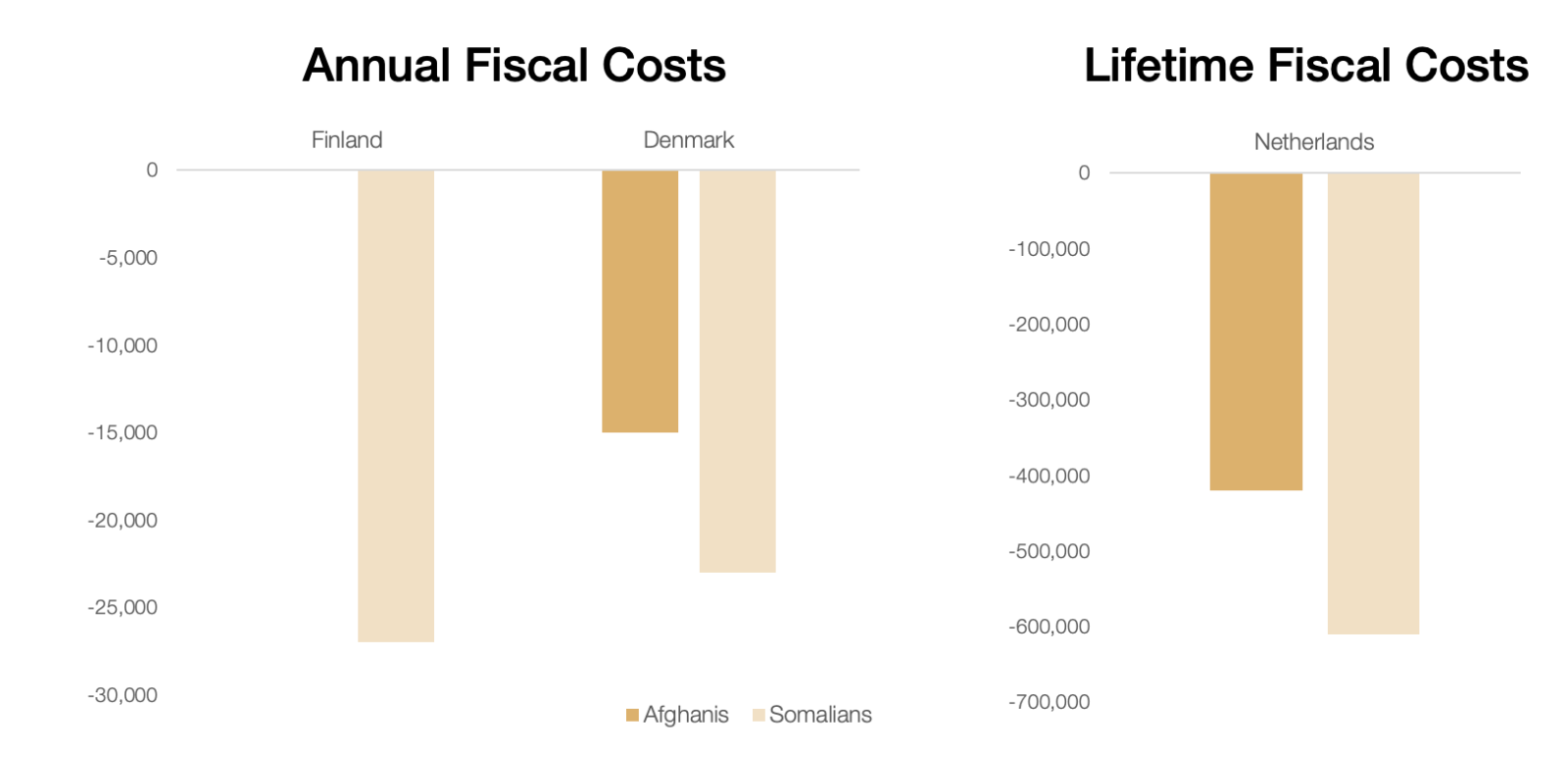
But Malays and Indonesians have very low crime rates; Colombians tend to have high ones. Some African countries are more prone to crime and less prone to work than others. This should not be based on random lists of countries, but rather on some objective assessment of the immigrant’s potential based on the available information (in this case country of origin). If other data points are available, they should be taken into consideration too.
As mentioned, any country should have targets for immigrants (and maybe get as many high-skilled immigrants as possible!), and then people should use legal channels to tap into these quotas. Bypassing them is against the law, which means it’s against the will of the people, and they hate it.
And in Europe, the main path of illegal immigration is by boat: 150,000 people in 2025, ~80% of the total. This is also very dangerous for the immigrants, so it shouldn’t be incentivized.
Fortunately, we know how to stop it:
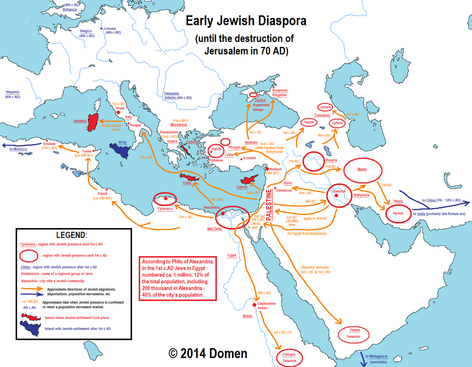
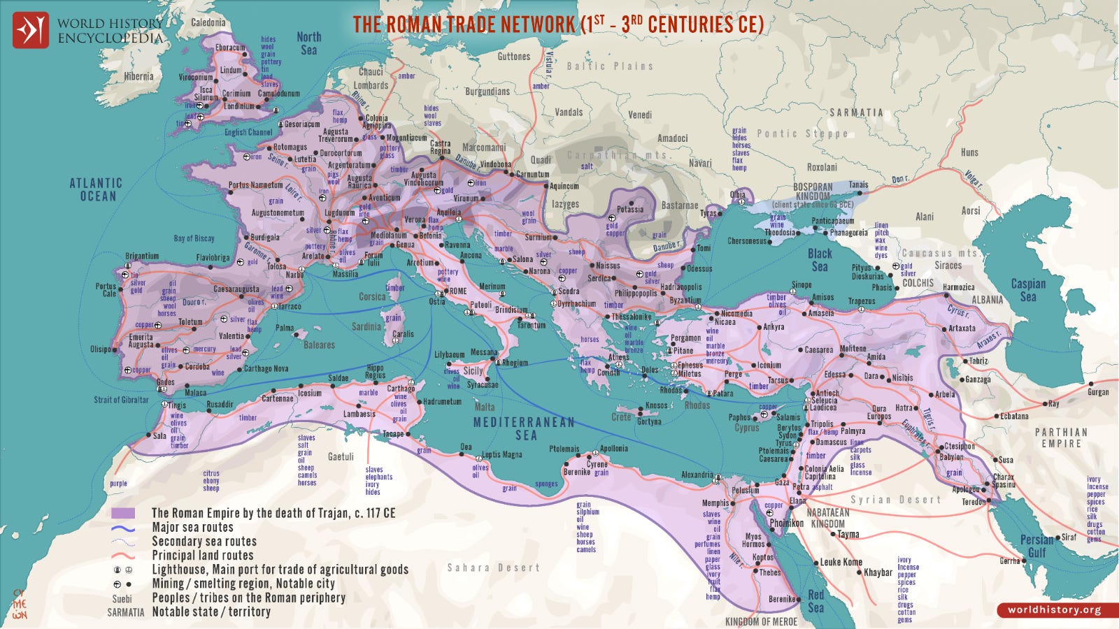
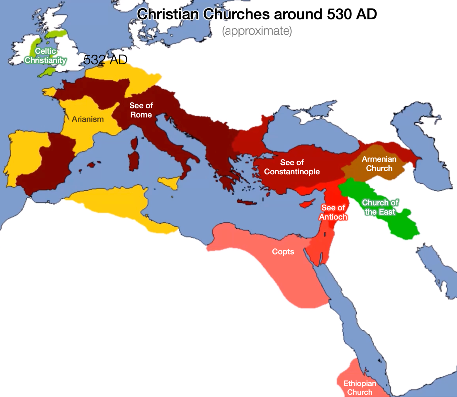
